


 Jun 8, 2021, 10:33 am
Last edit by: WineCountryUA
This is an archive thread, the active thread is United Pilot Q & A thread

United Pilot Q & A {Archive}
Apr 9, 2018, 9:34 am
#6646
FlyerTalk Evangelist
Join Date: Aug 2015
Posts: 11,470
I sat next to a really nice off-duty UA pilot on my last flight. While we were taxiing at O'Hare he took out his company iPad, connected to a special wifi, and showed me our location on the ground, flight plan, weather and other info for our flight. Is that a proprietary app and does everyone use it? Do you have the same wifi connection problems in the cockpit that passengers regularly experience?
 Apr 9, 2018, 9:38 am
#6647
Join Date: Jan 2016
Programs: UA 1K; *G, AA Plat
Posts: 1,700
*boots up Wireshark onboard the next time I see a pilot pull out an iPad while simultaneously praying that I don't get kicked off the flight.
Apr 9, 2018, 9:44 am
#6648
Join Date: Feb 2002
Location: BNA
Programs: HH Gold. (Former) UA PP, DL PM, PC Plat
Posts: 8,185
I sat next to a really nice off-duty UA pilot on my last flight. While we were taxiing at O'Hare he took out his company iPad, connected to a special wifi, and showed me our location on the ground, flight plan, weather and other info for our flight. Is that a proprietary app and does everyone use it? Do you have the same wifi connection problems in the cockpit that passengers regularly experience?
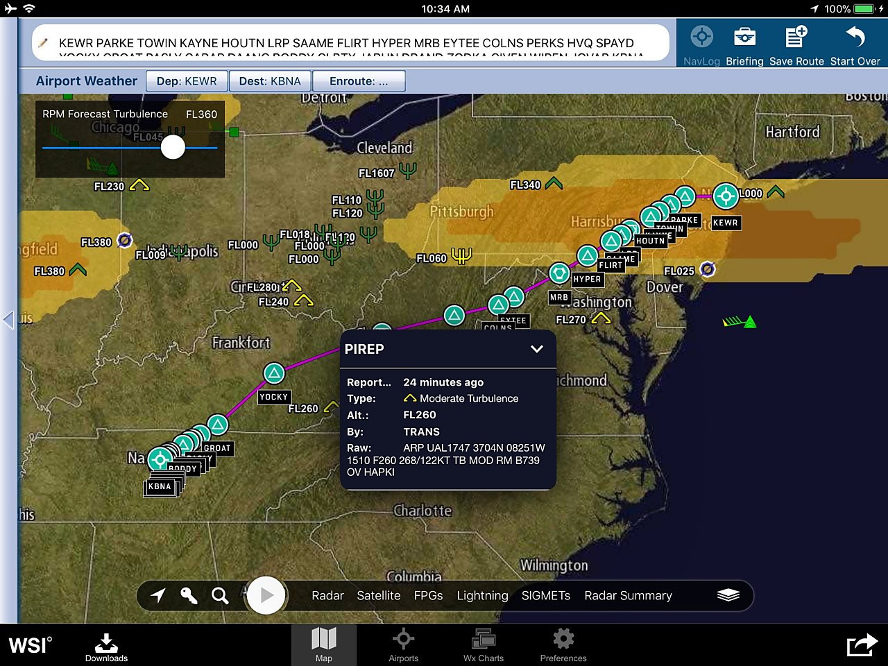
WSI is the authorized weather data provider for United Airlines. The app is the primary method for pilots to access WSI through our iPads. It is a service that the airline buys and, I assume, would be available for others to buy as well though I don't know if they have a comparable consumer-level service. I've attached a screenshot showing a flight from EWR to BNA and displaying the turbulence forecast at 36,000' along with current pilot reports for turbulence and icing. This is the display I use most often in flight but there are many other layers, as well as a large collection of aviation weather charts, available. I brought up the details of one of the moderate (yellow pyramid) turbulence reports. You can see that it was from a UAL 737-900 at 26,000' (FL260).
Another advantage of us having this connected app in the cockpit is that we're much more likely to notice when the internet is not working and reset it or write it up! We no longer depend on the flight attendants to pass along passenger complaints. The F/As handheld devices are also connected via the airplane's wifi. They have a lot of flight and passenger information available on them but I don't know the details.
 Apr 9, 2018, 11:37 am
#6649
Join Date: Jul 2009
Location: WAS
Programs: UA Silver, Marriott Gold, IHG Silver, Hilton Silver, Hertz PC, National Exec Elite, Avis PC
Posts: 1,297
Yup, that was the one. Thanks, Larry and clubord.
Apr 9, 2018, 8:23 pm
#6650
FlyerTalk Evangelist
Join Date: Aug 2015
Posts: 11,470
It is the same wifi (UNITED WIFI) that is available to the passengers. Some of our company apps are able to access data through the airplane's wifi inflight including the WSI weather app which is what you saw.
WSI is the authorized weather data provider for United Airlines. The app is the primary method for pilots to access WSI through our iPads. It is a service that the airline buys and, I assume, would be available for others to buy as well though I don't know if they have a comparable consumer-level service. I've attached a screenshot showing a flight from EWR to BNA and displaying the turbulence forecast at 36,000' along with current pilot reports for turbulence and icing. This is the display I use most often in flight but there are many other layers, as well as a large collection of aviation weather charts, available. I brought up the details of one of the moderate (yellow pyramid) turbulence reports. You can see that it was from a UAL 737-900 at 26,000' (FL260).
Another advantage of us having this connected app in the cockpit is that we're much more likely to notice when the internet is not working and reset it or write it up! We no longer depend on the flight attendants to pass along passenger complaints. The F/As handheld devices are also connected via the airplane's wifi. They have a lot of flight and passenger information available on them but I don't know the details.
img

This prompted me to remember I'd wanted to ask: does ATC typically direct approach to SFO above Half Dome? The first time I noticed it a few years ago, I thought it was just good fortune, but it's become something of a regular highlight for me when I come westward into SFO.
Apr 9, 2018, 8:40 pm
#6651
Join Date: Nov 1999
Location: if it's Thursday, this must be Belgium
Programs: UA 1K MM
Posts: 6,484
Thanks for posting. Who knew there were so many cactii between CLE and CVG.
This prompted me to remember I'd wanted to ask: does ATC typically direct approach to SFO above Half Dome? The first time I noticed it a few years ago, I thought it was just good fortune, but it's become something of a regular highlight for me when I come westward into SFO.
This prompted me to remember I'd wanted to ask: does ATC typically direct approach to SFO above Half Dome? The first time I noticed it a few years ago, I thought it was just good fortune, but it's become something of a regular highlight for me when I come westward into SFO.
http://155.178.201.160/d-tpp/1804/00375YOSEM.PDF
You can visualize where the path is by typing in the waypoints (like YOSEM, SNORA) at skyvector.com!
Apr 9, 2018, 8:50 pm
#6652
FlyerTalk Evangelist
Join Date: Aug 2015
Posts: 11,470
That is probably the YOSEM THREE standard arrival procedure, which does go right over Yosemite Natl Park:
http://155.178.201.160/d-tpp/1804/00375YOSEM.PDF
You can visualize where the path is by typing in the waypoints (like YOSEM, SNORA) at skyvector.com!
http://155.178.201.160/d-tpp/1804/00375YOSEM.PDF
You can visualize where the path is by typing in the waypoints (like YOSEM, SNORA) at skyvector.com!
 Apr 9, 2018, 9:56 pm
#6653
Join Date: Sep 2014
Posts: 2,531
That is probably the YOSEM THREE standard arrival procedure, which does go right over Yosemite Natl Park:
http://155.178.201.160/d-tpp/1804/00375YOSEM.PDF
You can visualize where the path is by typing in the waypoints (like YOSEM, SNORA) at skyvector.com!
http://155.178.201.160/d-tpp/1804/00375YOSEM.PDF
You can visualize where the path is by typing in the waypoints (like YOSEM, SNORA) at skyvector.com!
Apr 10, 2018, 3:06 am
#6654
FlyerTalk Evangelist
Join Date: May 2007
Location: Houston
Programs: UA Plat, Marriott Gold
Posts: 12,694
But no idea why it is serif.
Apr 10, 2018, 2:00 pm
#6655
Join Date: Feb 2002
Location: BNA
Programs: HH Gold. (Former) UA PP, DL PM, PC Plat
Posts: 8,185
So, why is the seatbelt sign on even though it's smooth? Often, it's because you're flying through an area of either forecast turbulence (yellow 'clouds') or near turbulence PIREPS. If the bumps never materialize it may be that we were able to use the information from the WSI app, and other sources, to avoid it.
Apr 10, 2018, 5:08 pm
#6656
FlyerTalk Evangelist
Join Date: Aug 2015
Posts: 11,470
Those would be pilot reports (PIREPS) of icing. Green is light icing just as the green "pyramids" are light turbulence. Yellow is moderate. Red is severe. Extreme is also red but is a different symbol. A red box would be low-level wind shear.
So, why is the seatbelt sign on even though it's smooth? Often, it's because you're flying through an area of either forecast turbulence (yellow 'clouds') or near turbulence PIREPS. If the bumps never materialize it may be that we were able to use the information from the WSI app, and other sources, to avoid it.
So, why is the seatbelt sign on even though it's smooth? Often, it's because you're flying through an area of either forecast turbulence (yellow 'clouds') or near turbulence PIREPS. If the bumps never materialize it may be that we were able to use the information from the WSI app, and other sources, to avoid it.
Apr 10, 2018, 5:22 pm
#6657
Join Date: Feb 2002
Location: BNA
Programs: HH Gold. (Former) UA PP, DL PM, PC Plat
Posts: 8,185
https://business.weather.com/news/ws...ovide-tracking
That one is showing light turbulence and winds of 90kts out of the west. Tapping the icon would bring up the detailed report.
Apr 10, 2018, 5:28 pm
#6658
FlyerTalk Evangelist
Join Date: Aug 2015
Posts: 11,470
That is an automated wind and turbulence report from the TAPS system.
https://business.weather.com/news/ws...ovide-tracking
That one is showing light turbulence and winds of 90kts out of the west. Tapping the icon would bring up the detailed report.
https://business.weather.com/news/ws...ovide-tracking
That one is showing light turbulence and winds of 90kts out of the west. Tapping the icon would bring up the detailed report.
Apr 10, 2018, 6:11 pm
#6659
Join Date: Oct 2006
Location: IAD
Programs: UA 1K 2MM, Hilton Diamond
Posts: 565
That is an automated wind and turbulence report from the TAPS system.
https://business.weather.com/news/ws...ovide-tracking
That one is showing light turbulence and winds of 90kts out of the west. Tapping the icon would bring up the detailed report.
https://business.weather.com/news/ws...ovide-tracking
That one is showing light turbulence and winds of 90kts out of the west. Tapping the icon would bring up the detailed report.
May 23, 2018, 11:07 am
#6660
Join Date: Feb 2016
Location: ORD | LGA | 2E
Programs: UA GS 1.6MM UC | AA CK 0.7MM AC | Bonvoy Ambassador | Hyatt Globalist | Hertz PC
Posts: 1,054
I thought this may be a good place to mention this but in the LAX UC today they announced an "ask a Pilot" hour where a UA pilot walked the club and talked with pax. I'm not LAX-based anymore so not sure if this has been going on for a long time or not but I thought it was a great touch.
Are pilots asked to volunteer for that? I'm curious what the impetus for that idea was.
Are pilots asked to volunteer for that? I'm curious what the impetus for that idea was.