


Four Corners
 Jan 24, 2011, 1:44 pm
#1
Original Poster
Join Date: Jan 2010
Location: SMF, OGG
Programs: UA MM, Alaska Airlines MVP
Posts: 197
Four Corners
Last October my husband and I decided it was time to trade in some of our hard-earned Mileage Plus miles and take a weekend getaway trip to the geographic center of all things road-trip in the West- The Four Corners. 4 states, over 1200 miles, and 2GB of photos later, this is our story:
DAY 1
The journey began at 6:05am in Sacramento, CA (SMF) where we caught the first flight of the day to Denver. After a short layover and an hour ride over the Rocky Mountains in a DASH-8, we landed in Durango, CO (DRO) just before noon. We grabbed our bags, picked up our jalopy-of-a-rental car, inhaled a couple burgers at the local Sonic Drive-In and hit the road.
We started the afternoon in Mesa Verde National Park by taking a leisurely-paced self-guided tour of the Spruce Tree House. The next few hours were spent franticly circling the Cliff Palace and Mesa Top loop roads (several times) while braving car troubles, in hopes of seeing the rest of the park’s sites…in the daylight.
After a mandatory stop at the Far View Visitor Center to stamp our National Park Passports and purchase tickets ($3), we proceeded to the Cliff Palace to take the ranger-guided tour there. We descended the staircase along the side of a huge rock and stood at the bottom in awe of the ancient dwellings, that in my opinion, make Mesa Verde a must-visit if you are in the region. The ascent back to the parking lot was up a series of wood ladders, modeled after the ones the people had used over a thousand years ago.
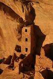
Square Tower House Ruin, Mesa Verde
Sunset time was spent snapping pictures of the Square Tower House ruin as it transformed from white to yellow to orange to a fiery red with the fading light. We then made the one-and-a-half hour drive back to Durango, exchanged our heap-of-junk-rental car (after a lengthy phone dispute with Hertz), and called it a night.
DAY 1
The journey began at 6:05am in Sacramento, CA (SMF) where we caught the first flight of the day to Denver. After a short layover and an hour ride over the Rocky Mountains in a DASH-8, we landed in Durango, CO (DRO) just before noon. We grabbed our bags, picked up our jalopy-of-a-rental car, inhaled a couple burgers at the local Sonic Drive-In and hit the road.
We started the afternoon in Mesa Verde National Park by taking a leisurely-paced self-guided tour of the Spruce Tree House. The next few hours were spent franticly circling the Cliff Palace and Mesa Top loop roads (several times) while braving car troubles, in hopes of seeing the rest of the park’s sites…in the daylight.
After a mandatory stop at the Far View Visitor Center to stamp our National Park Passports and purchase tickets ($3), we proceeded to the Cliff Palace to take the ranger-guided tour there. We descended the staircase along the side of a huge rock and stood at the bottom in awe of the ancient dwellings, that in my opinion, make Mesa Verde a must-visit if you are in the region. The ascent back to the parking lot was up a series of wood ladders, modeled after the ones the people had used over a thousand years ago.
Square Tower House Ruin, Mesa Verde
Sunset time was spent snapping pictures of the Square Tower House ruin as it transformed from white to yellow to orange to a fiery red with the fading light. We then made the one-and-a-half hour drive back to Durango, exchanged our heap-of-junk-rental car (after a lengthy phone dispute with Hertz), and called it a night.
Last edited by hulagrrl210; Oct 9, 2012 at 11:39 am Reason: pictures added
 Jan 24, 2011, 1:44 pm
#2
Original Poster
Join Date: Jan 2010
Location: SMF, OGG
Programs: UA MM, Alaska Airlines MVP
Posts: 197
Four Corners continued
DAY 2
We were out of bed and on the road before the sun came up, headed north over the Million Dollar Highway. I was glad we had upgraded cars, because if not, with three passes over 10,000 ft elevation, we might still be there, foot on the floor, traversing that two-lane road. We picked this time of year in hopes of seeing some fall colors, but much to our disappointment, the aspens in the high elevation had already turned. We did, however, get to see something we didn’t expect- snow.
Our first stop was the small mining town of Silverton. At this point the sun was just starting to light up the mountain peaks. It was apparent that not much was happening here circa 7am, so we continued our journey. The next stretch of road was perhaps the most scenic and exciting mountain driving of the trip. We crossed the appropriately-named Red Mountain Pass (11,000 ft.+.), drove past some mines, and descended into a spectacular box-canyon, home to the little town of Ouray. Continuing north, we passed through Ridgeway, where we got our first panoramic view of the San Juan Mountains and encountered a menacing grizzly bear standing tall in the back of a 1-ton pickup truck. He looked so convincing, I had to do a double take to confirm that in reality it was a roadside advertisement for the local taxidermy shop.
Black Canyon of the Gunnison National Park is where we were headed next. As we approached the area, it didn’t seem all that scenic. My husband and I were like, “Where’s the park?” Spoiled by what we had seen earlier that morning, we weren’t all the impressed…until we got there. The canyon is deeper than it is wide, the walls far steeper than those of its rival The Grand Canyon.
Black Canyon of the Gunnison National Park
Next we stopped long enough for another fast-food lunch at Chipotle in Grand Junction and picked up I-70 westbound towards Utah. We had initially planned to visit the Colorado National Monument, but decided to pass it up in the interest of time. After that we amended our trip-plan a second time, and decided to take a “shortcut” to Moab along the Colorado River Scenic Byway.
We swung by Arches National Park long enough to get another passport stamp.. We had explored the park thoroughly in 2004, and passed up this subsequent opportunity to in favor of continuing on up the road the Canyonlands‘ Island in the Sky district.
At this point I must digress for a second. What I am sharing next is somewhat-privileged information, and with the expectation that you will use your knowledge for good, not evil. Many archeological sites in the Southwest remain accessible to the public only as long as people respect them. Be cool. Pretend you are in a museum, like the kind where you are NOT ALLOWED TO TOUCH ANYTHING. Do this so that that future generations and even other people in this generation can continue to enjoy them. *end rant*
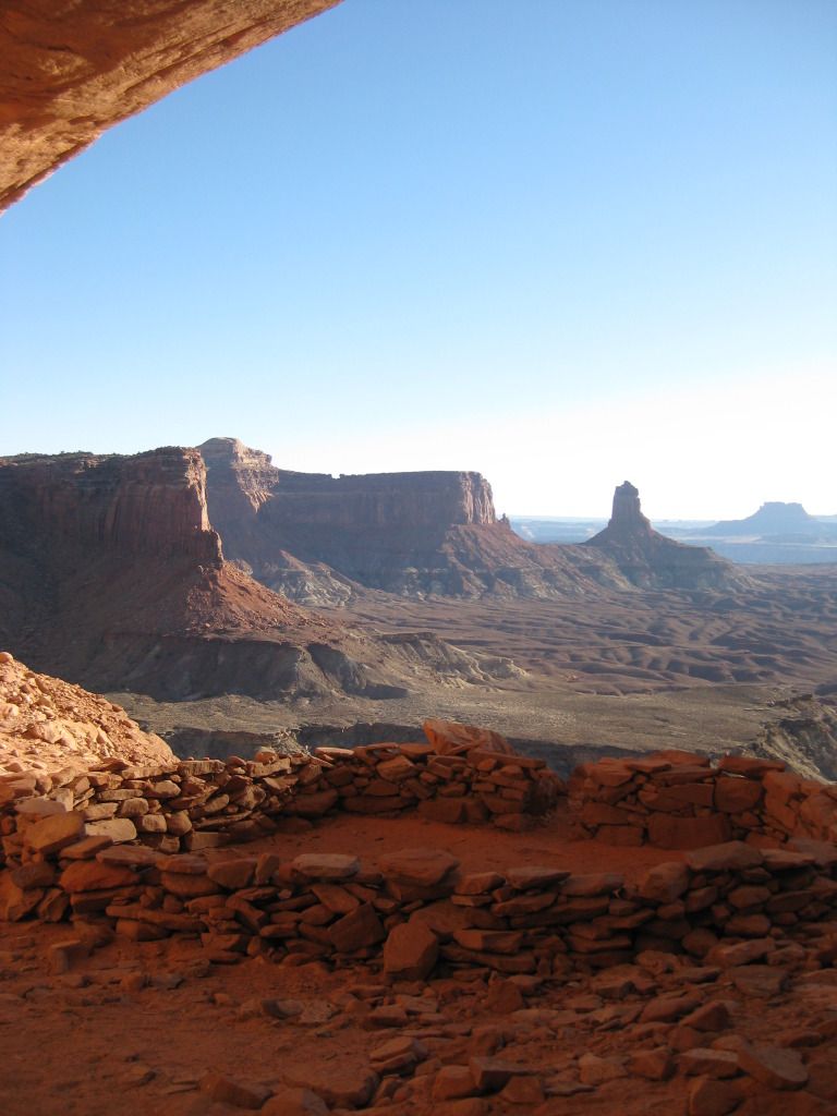
Canyonlands National Park
So, if you want to go to False Kiva there are a few things that you need to do. First of all, you have to find out about it. I did after years of staring at Peter Lik‘s photograph “Ancient Spirit”, and wondering where it was taken. With my only hint being Canyonlands National Park, I turned to Google unsuccessfully and finally had to consult a few photography books in order to come up with the location name. Next you have to go to see the ranger at the Island in the Sky Visitor Center, drop the name “False Kiva” and ask really nicely to see “the book”. He/she will unveil a small binder with instructions on how to get there and undoubtedly give you the same lecture that I just did.
After braving the cactus-filled dry wash we stumbled down the talus covered slope, mindful to steer well clear of the 1,000 drop into the abyss below. We turned a corner and there is was, nestled above in a small alcove at the base of a several-hundred-foot-tall sandstone cliff face. A short climb later we arrived at the site and found ourselves in the company of a very annoying little man, who insisted on offering us his unsolicited photo-taking tips. The dude would not shut up. For about 45 minutes we politely ignored him, assuming that he had really no idea what he was even talking about anyway. Not like we did either; I think I know more about rocket science and underwater basket weaving than I do the inner workings of my new Canon Digital Rebel Xti camera. The guy lost any and all remaining credibility when he made his exit just before the light got good, and thankfully we were left in peace to enjoy the of the moment undisturbed. We took a few good pictures, none of which came out looking anything like Peter Lik‘s, but that’s ok. It was an experience and one that I will remember for the rest of my life.
Right at sunset we conveniently found ourselves at the Grand View Point Overlook. At 1,000 above the rest of the Colorado Plateau, it became evident why this part of the park is called Island in the Sky. Below the Green River merges with the Colorado, and flows west in the same direction as the fading light.
We were out of bed and on the road before the sun came up, headed north over the Million Dollar Highway. I was glad we had upgraded cars, because if not, with three passes over 10,000 ft elevation, we might still be there, foot on the floor, traversing that two-lane road. We picked this time of year in hopes of seeing some fall colors, but much to our disappointment, the aspens in the high elevation had already turned. We did, however, get to see something we didn’t expect- snow.
Our first stop was the small mining town of Silverton. At this point the sun was just starting to light up the mountain peaks. It was apparent that not much was happening here circa 7am, so we continued our journey. The next stretch of road was perhaps the most scenic and exciting mountain driving of the trip. We crossed the appropriately-named Red Mountain Pass (11,000 ft.+.), drove past some mines, and descended into a spectacular box-canyon, home to the little town of Ouray. Continuing north, we passed through Ridgeway, where we got our first panoramic view of the San Juan Mountains and encountered a menacing grizzly bear standing tall in the back of a 1-ton pickup truck. He looked so convincing, I had to do a double take to confirm that in reality it was a roadside advertisement for the local taxidermy shop.
Black Canyon of the Gunnison National Park is where we were headed next. As we approached the area, it didn’t seem all that scenic. My husband and I were like, “Where’s the park?” Spoiled by what we had seen earlier that morning, we weren’t all the impressed…until we got there. The canyon is deeper than it is wide, the walls far steeper than those of its rival The Grand Canyon.
Black Canyon of the Gunnison National Park
Next we stopped long enough for another fast-food lunch at Chipotle in Grand Junction and picked up I-70 westbound towards Utah. We had initially planned to visit the Colorado National Monument, but decided to pass it up in the interest of time. After that we amended our trip-plan a second time, and decided to take a “shortcut” to Moab along the Colorado River Scenic Byway.
We swung by Arches National Park long enough to get another passport stamp.. We had explored the park thoroughly in 2004, and passed up this subsequent opportunity to in favor of continuing on up the road the Canyonlands‘ Island in the Sky district.
At this point I must digress for a second. What I am sharing next is somewhat-privileged information, and with the expectation that you will use your knowledge for good, not evil. Many archeological sites in the Southwest remain accessible to the public only as long as people respect them. Be cool. Pretend you are in a museum, like the kind where you are NOT ALLOWED TO TOUCH ANYTHING. Do this so that that future generations and even other people in this generation can continue to enjoy them. *end rant*
Canyonlands National Park
So, if you want to go to False Kiva there are a few things that you need to do. First of all, you have to find out about it. I did after years of staring at Peter Lik‘s photograph “Ancient Spirit”, and wondering where it was taken. With my only hint being Canyonlands National Park, I turned to Google unsuccessfully and finally had to consult a few photography books in order to come up with the location name. Next you have to go to see the ranger at the Island in the Sky Visitor Center, drop the name “False Kiva” and ask really nicely to see “the book”. He/she will unveil a small binder with instructions on how to get there and undoubtedly give you the same lecture that I just did.
After braving the cactus-filled dry wash we stumbled down the talus covered slope, mindful to steer well clear of the 1,000 drop into the abyss below. We turned a corner and there is was, nestled above in a small alcove at the base of a several-hundred-foot-tall sandstone cliff face. A short climb later we arrived at the site and found ourselves in the company of a very annoying little man, who insisted on offering us his unsolicited photo-taking tips. The dude would not shut up. For about 45 minutes we politely ignored him, assuming that he had really no idea what he was even talking about anyway. Not like we did either; I think I know more about rocket science and underwater basket weaving than I do the inner workings of my new Canon Digital Rebel Xti camera. The guy lost any and all remaining credibility when he made his exit just before the light got good, and thankfully we were left in peace to enjoy the of the moment undisturbed. We took a few good pictures, none of which came out looking anything like Peter Lik‘s, but that’s ok. It was an experience and one that I will remember for the rest of my life.
Right at sunset we conveniently found ourselves at the Grand View Point Overlook. At 1,000 above the rest of the Colorado Plateau, it became evident why this part of the park is called Island in the Sky. Below the Green River merges with the Colorado, and flows west in the same direction as the fading light.
Last edited by hulagrrl210; Oct 9, 2012 at 11:41 am Reason: pictures added
Jan 24, 2011, 1:45 pm
#3
Original Poster
Join Date: Jan 2010
Location: SMF, OGG
Programs: UA MM, Alaska Airlines MVP
Posts: 197
DAY 3
I am not a morning person. I know you’re reading this, a bit confused, recalling the 6am flight on Day 1 and numerous references to first light on Day 2, but I’m really not a morning person. So bucking the trend of well, my entire life, I decided to wake up early again on Day 3. On a whim (we’d already had another full day planned), my husband decided we wanted to get up and see the sunrise at Mesa Arch. We had unsuccessfully tried to be there for it at about 10am in the summer of 2004; I really had no idea that the sun came up like 4 hours before that. This trip being in October made it a little easier with a later sunrise, but it was still very early when we left Moab and returned to Canyonlands.
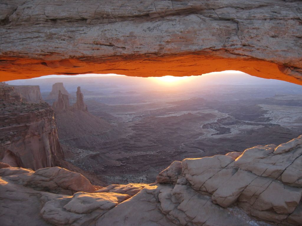
Mesa Arch at Sunrise
We arrived when it was still dark and made the short hike to the arch. I’d expected we’d be the only ones crazy enough to get up at the hour, and I was wrong. There were probably two dozen other photographers there, elbowing each other to set up their tri-pods in prime locations. The sunrise was spectacular, as expected, but it was sadly upstaged by the circus that was unfolding. There was such a competitive vibe with people flaunting thousands of dollars (maybe tens our thousands) of equipment and arguing about what times were best to photograph various other locations around the park. I was beginning not to like this crowd. They seemed judgmental and they were rude. I’ll admit I had no idea what I was doing. Shooting into the light was proving to be quite tricky. I’d maybe spent 10 minutes reviewing the instruction booklet for my fancy new camera the night before, and by no means had a firm grasp of the subject matter. However, I don’t think I was alone judged by the numerous either really dark or overexposed images appearing on the LCD screens around me. I wasn’t about to waste this opportunity (or get up at 4 or 5am to do it again) so I quickly abandoned my Canon Digital Rebel Xti in favor of my trusty Canon SD400 point-and-shoot. It’s amazing how a camera that had been through the washing machine in one of my jacket pockets seemed to be outperforming everyone else’s. That made me smile.
Shortly after sunrise, the crowd disappeared, and we were left to admire the beauty of Mesa Arch, without all the drama. It reminded me why I had been so impressed with this spot 5 years before when we had visited. Even after the sun climbs high in the sky, and the photographers seem to lose interest, the underside of the arch has an amazing warm orange glow. I walked across the top, as I had during my previous visit, and looked down to where the light seemed to be coming from 1,000 feet below. I usually get really bad vertigo and shy away from the edges of cliffs, but this was somehow different. I wasn’t scared at all, despite there being a rather large gap on the other side as well. Being up this high felt empowering.
As I mentioned before we’d already had a full day planned which didn’t include sunrise at Mesa Arch, so at this point we were a couple hours behind schedule. I had two other potential sites I wanted to check out and if I wanted to photograph them, according to what I’d been told, it had to be in the morning light.
We arrived at the Mule Canyon trailhead, after one very brief stop en-route at the uber- kitschy Hole in the Rock south of Moab. The drive took had taken a few hours and we knew when we started our hike to House on Fire Ruin that the best light had already passed. The directions I had on how to get there were vague- follow the creek about a mile, turn the corner, look to the right above you- seemed simple enough. However, in typical “easier said, than done” fashion, with no way or measuring, 1/2 of a mile seemed like about 5. The creek/dry wash had lots of turns in it, I saw nothing resembling ruins, and soon enough we had no idea where we were going. I wouldn’t say we were lost; we easily could have turned around, but instead we continued.
We met a young family hiking on the trail, who had never heard of where we were going, but agreed it sounded cool and wanted to help us look for it. Positive that we had already traveled way more than a mile, we abandoned the well-trod path to examine the surrounding area…and guess who we found…False Kiva dude. “My book says follow the creek about a mile, turn the corner, and look on your right. Have you guys seen the creek?” I was shocked he’d made it this far, and kind of curious how he did it. Surely a self-proclaimed expert would know that the best time to photograph House on Fire was two hours ago, and then I realized he’d probably been out there, stumbling through the bushes and climbing over boulders, all morning long.
House of Fire Ruin
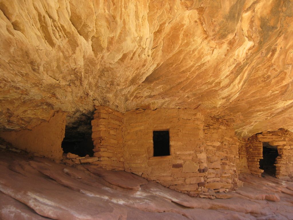
So it turned out the House of Fire was just about 20 yards away around the next turn once we got back on the trail. It was a cute little ruin. The striations in the orange colored rock above actually looked like flames, hence the clever name. We took a few photos there, listened as False Kiva dude bragged to the family we’d just met, and shortly after returned on the trail back to the car. It actually seemed like a mile this time.
Our next stop was Fallen Roof Ruin. By the time we reached the trailhead it was early afternoon. With directions reading something like, “turn left at the hoodoo”, I decided this time I was going to bust out the handheld GPS. My husband and I sprawled the rest of our gear out on the hood of our rental car and stood there trying to figure out how to input coordinates. If you haven’t already guessed, I’m not a read-the-instructions-kind-of-gal, rather more the press-buttons-and-ask-questions-later type. While we were messing around, a rather mysterious older man pulled up next to us his beat up pickup truck. He was going to Fallen Roof too. He politely asked if we knew how to get there, and I gave him my best, yet still-vague directions. I also offered the GPS coordinates, but he graciously declined. “No thanks, I don’t use those things.”
The old man probably had a 10 minute head start by the time we hit the trail. The cool thing about the GPS is that it shows you exactly where you are going, but it doesn’t really tell you the best way to get there. We managed to find our own way down the canyon wall and onto a primitive trail that took us the rest of the way. Sure enough right past the hoodoo, there is was, high above and well camouflaged. We could have easily walked right past it had it not been for our little Garmin saying it was 10 yards away with an arrow indicating the direction.
We scaled the slick rock and shortly after arrived at the site. The old man was already there taking a few photos with an old-school film version on my Canon Digital SLR. He quickly noticed our new camera and asked how we liked it. He said he was thinking of getting one too, but decided against it, citing his old one worked fine and he knew how to use it. I admitted I was still learning how to use mine, and we kind of laughed together. He was cool. Our conversation was brief. Unlike so many of the photographers we’d met along the way, he didn’t waste our time with a bunch of shameless self-promotion. The three of us sat there among the ruins, in silent appreciation of the tranquil place we had found.
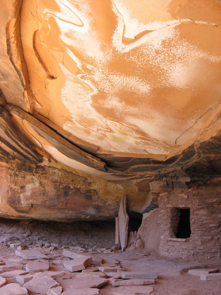
Fallen Roof Ruin got its name due to the unique “ceiling” it has. The floor is littered with large piece of rock that have been dislodged from above. What’s left behind is a really cool swirled pattern of white mineral residue which contrasts the reddish sandstone. On one side of the ceiling there are some handprints- a reminder that long ago, once upon a time, someone used to live there.
Fallen Roof Ruin
So imagine you are traveling along and you arrive at a stunning vista overlooking a vast desert. Below you there is some really cool stuff: Valley of the Gods, Mexican Hat, and Monument Valley, which is faintly visible far off in the distance. You decide it looks so cool that you really want to go down there are check it all out. You see a road below, but you’re not entirely sure how to get there from here because there’s the problem of this 1,100 foot cliff that you’re now at the edge of. The pavement disappears, and after 3 miles and a series of switchbacks you are at the bottom. You have just descended Mokee Dugway.
By the time we got to Monument Valley is was late afternoon. The entire drive down highway 163 looks like the set of an old western movie, as it should considering so many were filmed here. We approached the tribal park visitor center and paid our entrance fee. At the time seemed like of a mild form of extortion, but this is their land and that’s the way it is. If you’ve been there, you probably know what I’m talking about. From this point you can barely see the tops of the “Mittens”, and you’re forced to hand over the cash in order to continue less than 100 yards to the parking lot for the full view. The buttes are spectacular indeed, almost other-worldly. Our visit that day was brief. In 2003, we had driven the entire self-guided tour through the valley, which I definitely recommend if you’ve got them time. Unfortunately for us, daylight was a commodity that we were running out of, so are abbreviated experience that day consisted of enjoying a cold non-alcoholic beverage on the terrace and having a stranger snap a few pictures of us with Left Mitten, Right Mitten and Merrick Butte in the background.
The Navajo Nation prohibits the sale of alcohol, and I’d be lying if I didn’t admit that was part of the reason why we decided to stay a little out of the way in Farmington, NM that night. We passed by Shiprock just after sunset, so we didn’t stop. We did stop however at a small convenience store on the border of the reservation to buy a fifth of Jack Daniels and a few bottles of Coke to take to our hotel with us. We had Subway for dinner and the rest of the evening was spent splashing around in the pool at the Holiday Inn Express.
I am not a morning person. I know you’re reading this, a bit confused, recalling the 6am flight on Day 1 and numerous references to first light on Day 2, but I’m really not a morning person. So bucking the trend of well, my entire life, I decided to wake up early again on Day 3. On a whim (we’d already had another full day planned), my husband decided we wanted to get up and see the sunrise at Mesa Arch. We had unsuccessfully tried to be there for it at about 10am in the summer of 2004; I really had no idea that the sun came up like 4 hours before that. This trip being in October made it a little easier with a later sunrise, but it was still very early when we left Moab and returned to Canyonlands.
Mesa Arch at Sunrise
We arrived when it was still dark and made the short hike to the arch. I’d expected we’d be the only ones crazy enough to get up at the hour, and I was wrong. There were probably two dozen other photographers there, elbowing each other to set up their tri-pods in prime locations. The sunrise was spectacular, as expected, but it was sadly upstaged by the circus that was unfolding. There was such a competitive vibe with people flaunting thousands of dollars (maybe tens our thousands) of equipment and arguing about what times were best to photograph various other locations around the park. I was beginning not to like this crowd. They seemed judgmental and they were rude. I’ll admit I had no idea what I was doing. Shooting into the light was proving to be quite tricky. I’d maybe spent 10 minutes reviewing the instruction booklet for my fancy new camera the night before, and by no means had a firm grasp of the subject matter. However, I don’t think I was alone judged by the numerous either really dark or overexposed images appearing on the LCD screens around me. I wasn’t about to waste this opportunity (or get up at 4 or 5am to do it again) so I quickly abandoned my Canon Digital Rebel Xti in favor of my trusty Canon SD400 point-and-shoot. It’s amazing how a camera that had been through the washing machine in one of my jacket pockets seemed to be outperforming everyone else’s. That made me smile.
Shortly after sunrise, the crowd disappeared, and we were left to admire the beauty of Mesa Arch, without all the drama. It reminded me why I had been so impressed with this spot 5 years before when we had visited. Even after the sun climbs high in the sky, and the photographers seem to lose interest, the underside of the arch has an amazing warm orange glow. I walked across the top, as I had during my previous visit, and looked down to where the light seemed to be coming from 1,000 feet below. I usually get really bad vertigo and shy away from the edges of cliffs, but this was somehow different. I wasn’t scared at all, despite there being a rather large gap on the other side as well. Being up this high felt empowering.
As I mentioned before we’d already had a full day planned which didn’t include sunrise at Mesa Arch, so at this point we were a couple hours behind schedule. I had two other potential sites I wanted to check out and if I wanted to photograph them, according to what I’d been told, it had to be in the morning light.
We arrived at the Mule Canyon trailhead, after one very brief stop en-route at the uber- kitschy Hole in the Rock south of Moab. The drive took had taken a few hours and we knew when we started our hike to House on Fire Ruin that the best light had already passed. The directions I had on how to get there were vague- follow the creek about a mile, turn the corner, look to the right above you- seemed simple enough. However, in typical “easier said, than done” fashion, with no way or measuring, 1/2 of a mile seemed like about 5. The creek/dry wash had lots of turns in it, I saw nothing resembling ruins, and soon enough we had no idea where we were going. I wouldn’t say we were lost; we easily could have turned around, but instead we continued.
We met a young family hiking on the trail, who had never heard of where we were going, but agreed it sounded cool and wanted to help us look for it. Positive that we had already traveled way more than a mile, we abandoned the well-trod path to examine the surrounding area…and guess who we found…False Kiva dude. “My book says follow the creek about a mile, turn the corner, and look on your right. Have you guys seen the creek?” I was shocked he’d made it this far, and kind of curious how he did it. Surely a self-proclaimed expert would know that the best time to photograph House on Fire was two hours ago, and then I realized he’d probably been out there, stumbling through the bushes and climbing over boulders, all morning long.
House of Fire Ruin
So it turned out the House of Fire was just about 20 yards away around the next turn once we got back on the trail. It was a cute little ruin. The striations in the orange colored rock above actually looked like flames, hence the clever name. We took a few photos there, listened as False Kiva dude bragged to the family we’d just met, and shortly after returned on the trail back to the car. It actually seemed like a mile this time.
Our next stop was Fallen Roof Ruin. By the time we reached the trailhead it was early afternoon. With directions reading something like, “turn left at the hoodoo”, I decided this time I was going to bust out the handheld GPS. My husband and I sprawled the rest of our gear out on the hood of our rental car and stood there trying to figure out how to input coordinates. If you haven’t already guessed, I’m not a read-the-instructions-kind-of-gal, rather more the press-buttons-and-ask-questions-later type. While we were messing around, a rather mysterious older man pulled up next to us his beat up pickup truck. He was going to Fallen Roof too. He politely asked if we knew how to get there, and I gave him my best, yet still-vague directions. I also offered the GPS coordinates, but he graciously declined. “No thanks, I don’t use those things.”
The old man probably had a 10 minute head start by the time we hit the trail. The cool thing about the GPS is that it shows you exactly where you are going, but it doesn’t really tell you the best way to get there. We managed to find our own way down the canyon wall and onto a primitive trail that took us the rest of the way. Sure enough right past the hoodoo, there is was, high above and well camouflaged. We could have easily walked right past it had it not been for our little Garmin saying it was 10 yards away with an arrow indicating the direction.
We scaled the slick rock and shortly after arrived at the site. The old man was already there taking a few photos with an old-school film version on my Canon Digital SLR. He quickly noticed our new camera and asked how we liked it. He said he was thinking of getting one too, but decided against it, citing his old one worked fine and he knew how to use it. I admitted I was still learning how to use mine, and we kind of laughed together. He was cool. Our conversation was brief. Unlike so many of the photographers we’d met along the way, he didn’t waste our time with a bunch of shameless self-promotion. The three of us sat there among the ruins, in silent appreciation of the tranquil place we had found.
Fallen Roof Ruin got its name due to the unique “ceiling” it has. The floor is littered with large piece of rock that have been dislodged from above. What’s left behind is a really cool swirled pattern of white mineral residue which contrasts the reddish sandstone. On one side of the ceiling there are some handprints- a reminder that long ago, once upon a time, someone used to live there.
Fallen Roof Ruin
So imagine you are traveling along and you arrive at a stunning vista overlooking a vast desert. Below you there is some really cool stuff: Valley of the Gods, Mexican Hat, and Monument Valley, which is faintly visible far off in the distance. You decide it looks so cool that you really want to go down there are check it all out. You see a road below, but you’re not entirely sure how to get there from here because there’s the problem of this 1,100 foot cliff that you’re now at the edge of. The pavement disappears, and after 3 miles and a series of switchbacks you are at the bottom. You have just descended Mokee Dugway.
By the time we got to Monument Valley is was late afternoon. The entire drive down highway 163 looks like the set of an old western movie, as it should considering so many were filmed here. We approached the tribal park visitor center and paid our entrance fee. At the time seemed like of a mild form of extortion, but this is their land and that’s the way it is. If you’ve been there, you probably know what I’m talking about. From this point you can barely see the tops of the “Mittens”, and you’re forced to hand over the cash in order to continue less than 100 yards to the parking lot for the full view. The buttes are spectacular indeed, almost other-worldly. Our visit that day was brief. In 2003, we had driven the entire self-guided tour through the valley, which I definitely recommend if you’ve got them time. Unfortunately for us, daylight was a commodity that we were running out of, so are abbreviated experience that day consisted of enjoying a cold non-alcoholic beverage on the terrace and having a stranger snap a few pictures of us with Left Mitten, Right Mitten and Merrick Butte in the background.
The Navajo Nation prohibits the sale of alcohol, and I’d be lying if I didn’t admit that was part of the reason why we decided to stay a little out of the way in Farmington, NM that night. We passed by Shiprock just after sunset, so we didn’t stop. We did stop however at a small convenience store on the border of the reservation to buy a fifth of Jack Daniels and a few bottles of Coke to take to our hotel with us. We had Subway for dinner and the rest of the evening was spent splashing around in the pool at the Holiday Inn Express.
Last edited by hulagrrl210; Oct 9, 2012 at 11:49 am Reason: pictures added
Jan 24, 2011, 9:30 pm
#4
Join Date: May 2009
Location: Phoenix
Programs: AA-Gold, Hilton-Gold, Hyatt - Platinum
Posts: 227
We spent a long weekend in Monument Valley and never paid any entrance fees. We drove up from Flagstaff, stayed in Kayenta on the Navajo reservation and then drove to the valley and spent the afternoon exploring on horseback. I wondered if the fee was a new thing or just on certain entrances. But then we did leave Monument valley and drove north to Four Corners, still no entrance fees. It was incredible scenery, although very remote. The best food we had was when we ate small diners and ordered local favorites such as "indian Taco" which turned out to be Indian fry bread with beans, lettuce and other things stuffed inside. I could get used to those!
Jan 25, 2011, 2:33 am
#7
Join Date: Dec 2010
Programs: UA 1K
Posts: 232
We spent a long weekend in Monument Valley and never paid any entrance fees. We drove up from Flagstaff, stayed in Kayenta on the Navajo reservation and then drove to the valley and spent the afternoon exploring on horseback. I wondered if the fee was a new thing or just on certain entrances. But then we did leave Monument valley and drove north to Four Corners, still no entrance fees. It was incredible scenery, although very remote. The best food we had was when we ate small diners and ordered local favorites such as "indian Taco" which turned out to be Indian fry bread with beans, lettuce and other things stuffed inside. I could get used to those!
 Jan 25, 2011, 10:17 am
#8
Join Date: Jun 2003
Location: Denver CO
Programs: HHonors Gold, National Emerald Club, no airline affinity status
Posts: 3,349
I did a similar trip this past summer. I drove thru Western CO to Moab, down to Monument Valley, over to the Grand Canyon, back to the 4 Corners area (found the actual site closed for construction), to Durango and over the Million Dollar Highway. That was the scariest part of the trip. It was a great trip overall.
Jan 25, 2011, 10:38 am
#9
Join Date: May 2009
Location: Phoenix
Programs: AA-Gold, Hilton-Gold, Hyatt - Platinum
Posts: 227
Jan 25, 2011, 2:28 pm
#10
Original Poster
Join Date: Jan 2010
Location: SMF, OGG
Programs: UA MM, Alaska Airlines MVP
Posts: 197
Day 4
DAY 4
On day 4 we slept in, well kind of. At least this day it was already light when we hit the road, and I’m glad because we saw something interesting that we had missed in the darkness the night before- A giant “Jesus is Watching You” billboard strategically placed next to an adult video store. Finding it kind of funny and a bit odd at the same time, we of course had to pull over and take pictures of it. Sadly, however, this appeared to be the only interesting about Farmington, NM so soon enough we were back on the road.
White House Ruins
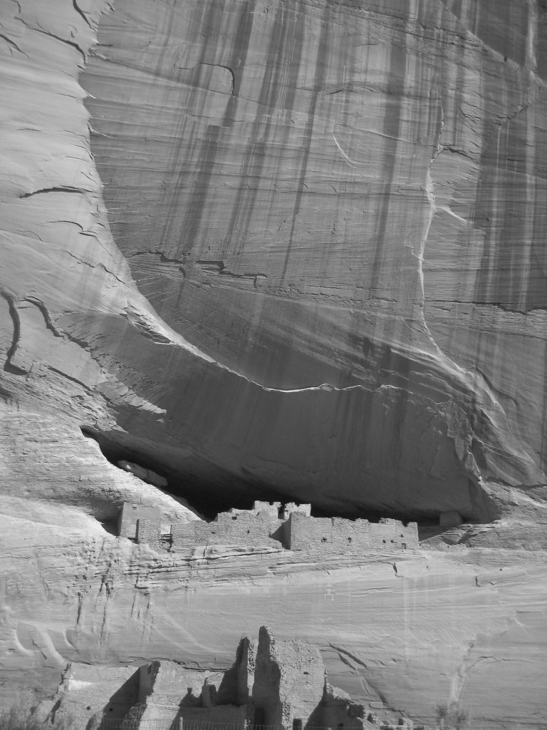
Canyon de Chelly was our first destination of the day, where we hiked to the very photogenic White House Ruins. Without hiring a Navajo guide, the only way to get there is by walking the 2.5 mile (rountrip) trail from the canyon rim about 800 feet above. I really didn’t know too much about the canyon before our visit and was surprised to learn that people still live there. We found ourselves sharing the path with a very elderly lady, her dog, and a flock of several hundred sheep. This level of authenticity had me thinking that this definitely not your average National Park site. There is basically no easy way to get there; Chinle, AZ is out of the way in the middle of nowhere (much of this day was spent driving) and that hike we took was not easy, however the visit was well worth the effort and I’m glad we did it.
So what would a trip be without a visit to the region’s namesake, the Four Corners… well, there’s not much to it- a plaque in the ground and a few plywood-sided gift shops, but seeing as how this tribal park was on the way back to Durango, we felt compelled to stop and get the obligatory pictures of ourselves standing in four states at a time (and in various poses). It seemed somehow fitting that this was the end of our trip, getting to revisit CO, UT, AZ and NM and all at once.
After a relatively short drive back to Durango, we had just enough time to wander around the town (something we had neglected to do on Day 1) before catching our mid-afternoon flight back to California. At the airport, we sat at the gate, scrolling through the hundreds of pictures we had taken before the plane arrived. Once we boarded, I think we both were sound asleep before the wheels ever left the ground. It had been a very long 4 days.
On day 4 we slept in, well kind of. At least this day it was already light when we hit the road, and I’m glad because we saw something interesting that we had missed in the darkness the night before- A giant “Jesus is Watching You” billboard strategically placed next to an adult video store. Finding it kind of funny and a bit odd at the same time, we of course had to pull over and take pictures of it. Sadly, however, this appeared to be the only interesting about Farmington, NM so soon enough we were back on the road.
White House Ruins
Canyon de Chelly was our first destination of the day, where we hiked to the very photogenic White House Ruins. Without hiring a Navajo guide, the only way to get there is by walking the 2.5 mile (rountrip) trail from the canyon rim about 800 feet above. I really didn’t know too much about the canyon before our visit and was surprised to learn that people still live there. We found ourselves sharing the path with a very elderly lady, her dog, and a flock of several hundred sheep. This level of authenticity had me thinking that this definitely not your average National Park site. There is basically no easy way to get there; Chinle, AZ is out of the way in the middle of nowhere (much of this day was spent driving) and that hike we took was not easy, however the visit was well worth the effort and I’m glad we did it.
So what would a trip be without a visit to the region’s namesake, the Four Corners… well, there’s not much to it- a plaque in the ground and a few plywood-sided gift shops, but seeing as how this tribal park was on the way back to Durango, we felt compelled to stop and get the obligatory pictures of ourselves standing in four states at a time (and in various poses). It seemed somehow fitting that this was the end of our trip, getting to revisit CO, UT, AZ and NM and all at once.
After a relatively short drive back to Durango, we had just enough time to wander around the town (something we had neglected to do on Day 1) before catching our mid-afternoon flight back to California. At the airport, we sat at the gate, scrolling through the hundreds of pictures we had taken before the plane arrived. Once we boarded, I think we both were sound asleep before the wheels ever left the ground. It had been a very long 4 days.
Last edited by hulagrrl210; Oct 9, 2012 at 11:44 am Reason: pictures added
Jan 25, 2011, 8:02 pm
#12
Join Date: Dec 2010
Programs: UA 1K
Posts: 232
DAY 4
On day 4 we slept in, well kind of. At least this day it was already light when we hit the road, and I�m glad because we saw something interesting that we had missed in the darkness the night before- A giant �Jesus is Watching You� billboard strategically placed next to an adult video store. Finding it kind of funny and a bit odd at the same time, we of course had to pull over and take pictures of it. Sadly, however, this appeared to be the only interesting about Farmington, NM so soon enough we were back on the road.
On day 4 we slept in, well kind of. At least this day it was already light when we hit the road, and I�m glad because we saw something interesting that we had missed in the darkness the night before- A giant �Jesus is Watching You� billboard strategically placed next to an adult video store. Finding it kind of funny and a bit odd at the same time, we of course had to pull over and take pictures of it. Sadly, however, this appeared to be the only interesting about Farmington, NM so soon enough we were back on the road.
Sounds like you didnt see much more then the south side hotel/gheto district. Not much to see there. As for the Jesus signs, you can thank our local church groups for that. I laugh every time I see it. There is 1 other porn shop on the other side of town and they have a Jesus bilboard over that one as well. Something tells me though, that the guys that still actually buy porn in shops as opposed to getting it off the net for free, arent bothered knowing Jesus watches them as they buy Penthouse.
Jan 25, 2011, 9:05 pm
#13
Join Date: Jul 2007
Location: ATL
Programs: Global Entry, UA, AA, BA, DL, Bonvoy
Posts: 281
So what would a trip be without a visit to the region�s namesake, the Four Corners� well, there�s not much to it- a plaque in the ground and a few plywood-sided gift shops, but seeing as how this tribal park was on the way back to Durango, we felt compelled to stop and get the obligatory pictures of ourselves standing in four states at a time (and in various poses).
Jan 25, 2011, 10:14 pm
#14
Original Poster
Join Date: Jan 2010
Location: SMF, OGG
Programs: UA MM, Alaska Airlines MVP
Posts: 197
Enjoyable trip report. It prompts me to want to visit several of the sites. After you visited the monument did you haul out your GPS and walk over the 1807 feet to visit the actual four corners? http://en.wikipedia.org/wiki/Four_Co...ument#Location

@bennijiggs, I think the Jesus sign is awsome! I would have gone all the way to Farmington just to see that, seriously!