DAY 3
I am not a morning person. I know you’re reading this, a bit confused, recalling the 6am flight on Day 1 and numerous references to first light on Day 2, but I’m really not a morning person. So bucking the trend of well, my entire life, I decided to wake up early again on Day 3. On a whim (we’d already had another full day planned), my husband decided we wanted to get up and see the sunrise at Mesa Arch. We had unsuccessfully tried to be there for it at about 10am in the summer of 2004; I really had no idea that the sun came up like 4 hours before that. This trip being in October made it a little easier with a later sunrise, but it was still very early when we left Moab and returned to Canyonlands.
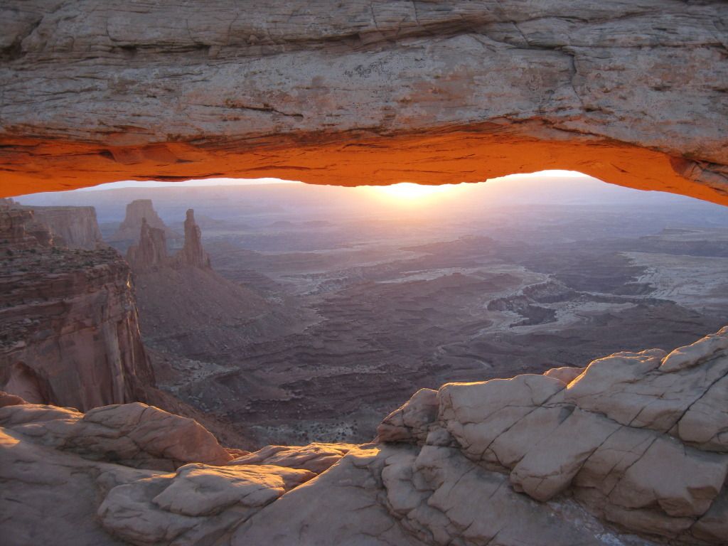
Mesa Arch at Sunrise
We arrived when it was still dark and made the short hike to the arch. I’d expected we’d be the only ones crazy enough to get up at the hour, and I was wrong. There were probably two dozen other photographers there, elbowing each other to set up their tri-pods in prime locations. The sunrise was spectacular, as expected, but it was sadly upstaged by the circus that was unfolding. There was such a competitive vibe with people flaunting thousands of dollars (maybe tens our thousands) of equipment and arguing about what times were best to photograph various other locations around the park. I was beginning not to like this crowd. They seemed judgmental and they were rude. I’ll admit I had no idea what I was doing. Shooting into the light was proving to be quite tricky. I’d maybe spent 10 minutes reviewing the instruction booklet for my fancy new camera the night before, and by no means had a firm grasp of the subject matter. However, I don’t think I was alone judged by the numerous either really dark or overexposed images appearing on the LCD screens around me. I wasn’t about to waste this opportunity (or get up at 4 or 5am to do it again) so I quickly abandoned my Canon Digital Rebel Xti in favor of my trusty Canon SD400 point-and-shoot. It’s amazing how a camera that had been through the washing machine in one of my jacket pockets seemed to be outperforming everyone else’s. That made me smile.
Shortly after sunrise, the crowd disappeared, and we were left to admire the beauty of Mesa Arch, without all the drama. It reminded me why I had been so impressed with this spot 5 years before when we had visited. Even after the sun climbs high in the sky, and the photographers seem to lose interest, the underside of the arch has an amazing warm orange glow. I walked across the top, as I had during my previous visit, and looked down to where the light seemed to be coming from 1,000 feet below. I usually get really bad vertigo and shy away from the edges of cliffs, but this was somehow different. I wasn’t scared at all, despite there being a rather large gap on the other side as well. Being up this high felt empowering.
As I mentioned before we’d already had a full day planned which didn’t include sunrise at Mesa Arch, so at this point we were a couple hours behind schedule. I had two other potential sites I wanted to check out and if I wanted to photograph them, according to what I’d been told, it had to be in the morning light.
We arrived at the Mule Canyon trailhead, after one very brief stop en-route at the uber- kitschy Hole in the Rock south of Moab. The drive took had taken a few hours and we knew when we started our hike to House on Fire Ruin that the best light had already passed. The directions I had on how to get there were vague- follow the creek about a mile, turn the corner, look to the right above you- seemed simple enough. However, in typical “easier said, than done” fashion, with no way or measuring, 1/2 of a mile seemed like about 5. The creek/dry wash had lots of turns in it, I saw nothing resembling ruins, and soon enough we had no idea where we were going. I wouldn’t say we were lost; we easily could have turned around, but instead we continued.
We met a young family hiking on the trail, who had never heard of where we were going, but agreed it sounded cool and wanted to help us look for it. Positive that we had already traveled way more than a mile, we abandoned the well-trod path to examine the surrounding area…and guess who we found…False Kiva dude. “My book says follow the creek about a mile, turn the corner, and look on your right. Have you guys seen the creek?” I was shocked he’d made it this far, and kind of curious how he did it. Surely a self-proclaimed expert would know that the best time to photograph House on Fire was two hours ago, and then I realized he’d probably been out there, stumbling through the bushes and climbing over boulders, all morning long.
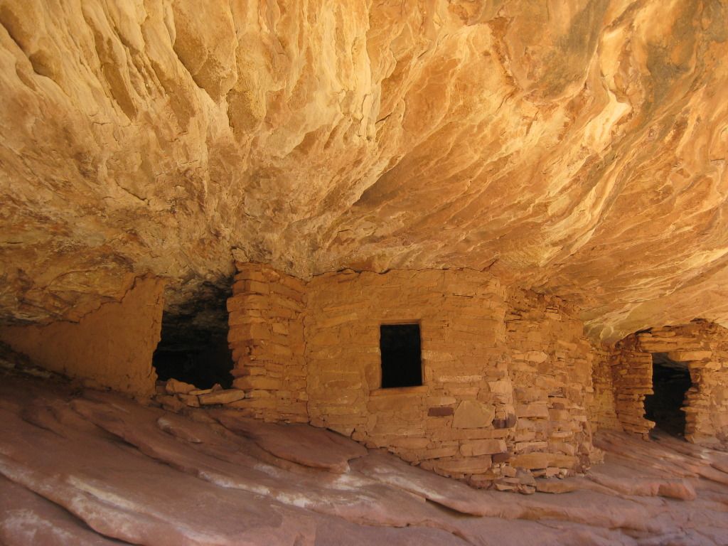
House of Fire Ruin
So it turned out the House of Fire was just about 20 yards away around the next turn once we got back on the trail. It was a cute little ruin. The striations in the orange colored rock above actually looked like flames, hence the clever name. We took a few photos there, listened as False Kiva dude bragged to the family we’d just met, and shortly after returned on the trail back to the car. It actually seemed like a mile this time.
Our next stop was Fallen Roof Ruin. By the time we reached the trailhead it was early afternoon. With directions reading something like, “turn left at the hoodoo”, I decided this time I was going to bust out the handheld GPS. My husband and I sprawled the rest of our gear out on the hood of our rental car and stood there trying to figure out how to input coordinates. If you haven’t already guessed, I’m not a read-the-instructions-kind-of-gal, rather more the press-buttons-and-ask-questions-later type. While we were messing around, a rather mysterious older man pulled up next to us his beat up pickup truck. He was going to Fallen Roof too. He politely asked if we knew how to get there, and I gave him my best, yet still-vague directions. I also offered the GPS coordinates, but he graciously declined. “No thanks, I don’t use those things.”
The old man probably had a 10 minute head start by the time we hit the trail. The cool thing about the GPS is that it shows you exactly where you are going, but it doesn’t really tell you the best way to get there. We managed to find our own way down the canyon wall and onto a primitive trail that took us the rest of the way. Sure enough right past the hoodoo, there is was, high above and well camouflaged. We could have easily walked right past it had it not been for our little Garmin saying it was 10 yards away with an arrow indicating the direction.
We scaled the slick rock and shortly after arrived at the site. The old man was already there taking a few photos with an old-school film version on my Canon Digital SLR. He quickly noticed our new camera and asked how we liked it. He said he was thinking of getting one too, but decided against it, citing his old one worked fine and he knew how to use it. I admitted I was still learning how to use mine, and we kind of laughed together. He was cool. Our conversation was brief. Unlike so many of the photographers we’d met along the way, he didn’t waste our time with a bunch of shameless self-promotion. The three of us sat there among the ruins, in silent appreciation of the tranquil place we had found.
Fallen Roof Ruin got its name due to the unique “ceiling” it has. The floor is littered with large piece of rock that have been dislodged from above. What’s left behind is a really cool swirled pattern of white mineral residue which contrasts the reddish sandstone. On one side of the ceiling there are some handprints- a reminder that long ago, once upon a time, someone used to live there.
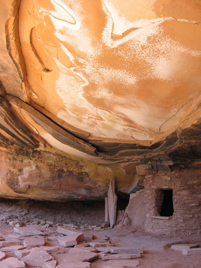
Fallen Roof Ruin
So imagine you are traveling along and you arrive at a stunning vista overlooking a vast desert. Below you there is some really cool stuff: Valley of the Gods, Mexican Hat, and Monument Valley, which is faintly visible far off in the distance. You decide it looks so cool that you really want to go down there are check it all out. You see a road below, but you’re not entirely sure how to get there from here because there’s the problem of this 1,100 foot cliff that you’re now at the edge of. The pavement disappears, and after 3 miles and a series of switchbacks you are at the bottom. You have just descended Mokee Dugway.
By the time we got to Monument Valley is was late afternoon. The entire drive down highway 163 looks like the set of an old western movie, as it should considering so many were filmed here. We approached the tribal park visitor center and paid our entrance fee. At the time seemed like of a mild form of extortion, but this is their land and that’s the way it is. If you’ve been there, you probably know what I’m talking about. From this point you can barely see the tops of the “Mittens”, and you’re forced to hand over the cash in order to continue less than 100 yards to the parking lot for the full view. The buttes are spectacular indeed, almost other-worldly. Our visit that day was brief. In 2003, we had driven the entire self-guided tour through the valley, which I definitely recommend if you’ve got them time. Unfortunately for us, daylight was a commodity that we were running out of, so are abbreviated experience that day consisted of enjoying a cold non-alcoholic beverage on the terrace and having a stranger snap a few pictures of us with Left Mitten, Right Mitten and Merrick Butte in the background.
The Navajo Nation prohibits the sale of alcohol, and I’d be lying if I didn’t admit that was part of the reason why we decided to stay a little out of the way in Farmington, NM that night. We passed by Shiprock just after sunset, so we didn’t stop. We did stop however at a small convenience store on the border of the reservation to buy a fifth of Jack Daniels and a few bottles of Coke to take to our hotel with us. We had Subway for dinner and the rest of the evening was spent splashing around in the pool at the Holiday Inn Express.