

















LiveATC.net feeds

 May 13, 2019 | 5:43 pm
#2


Join Date: Sep 2010
Location: KSUX
Posts: 919
There are different feeds for the different controllers though some smaller airports may have a single controller for Approach/Departure and another for Ground/Clearance.
These descriptions are greatly simplified but should give the idea what each does.
Approach controllers start funneling aircraft towards the airport from about 30-50nm out. They also clear aircraft to fly the approach pattern to their designated runway.
Departure controllers direct aircraft away from the airport and keep them separated from arriving aircraft before hand them off the the en-route "centers."
Clearance gives aircraft their routing. Often it may be the same as the flight plan filed by the pilot or airline but it may be different based on traffic, weather, etc.
Ground controls movement around the airport pretty much all movement on the airport except for the active runway(s). This can include movement on the apron/ramp, taxiways, inactive or closed runways, designated holding areas, etc.
Tower controls the active runways. The tower controller also clears aircraft to takeoff or land. They may also instruct aircraft to go around if needed. At some airports they may also control the taxiways near the active runways.
The live ATC feed for the airport here covers four frequencies. Tower, Approach and Departure (handled by the same controller), Emergency/Guard and the Minneapolis Center (ZMP) sector for this area. I wish I lived close enough to pick up the local controllers because it's really annoying to be listening to something interesting from the local controllers only to have them stepped on by the ZMP controller.
These descriptions are greatly simplified but should give the idea what each does.
Approach controllers start funneling aircraft towards the airport from about 30-50nm out. They also clear aircraft to fly the approach pattern to their designated runway.
Departure controllers direct aircraft away from the airport and keep them separated from arriving aircraft before hand them off the the en-route "centers."
Clearance gives aircraft their routing. Often it may be the same as the flight plan filed by the pilot or airline but it may be different based on traffic, weather, etc.
Ground controls movement around the airport pretty much all movement on the airport except for the active runway(s). This can include movement on the apron/ramp, taxiways, inactive or closed runways, designated holding areas, etc.
Tower controls the active runways. The tower controller also clears aircraft to takeoff or land. They may also instruct aircraft to go around if needed. At some airports they may also control the taxiways near the active runways.
The live ATC feed for the airport here covers four frequencies. Tower, Approach and Departure (handled by the same controller), Emergency/Guard and the Minneapolis Center (ZMP) sector for this area. I wish I lived close enough to pick up the local controllers because it's really annoying to be listening to something interesting from the local controllers only to have them stepped on by the ZMP controller.
Feb 13, 2023 | 1:43 pm
#3
Original Poster
FlyerTalk Evangelist


Join Date: Nov 2002
Location: ORD
Posts: 14,773
Bumping my old thread with more questions 
There are a lot of items listed for each feed for my local airport (ORD) on liveatc.net.
And I guess most of all, if I were interested in a particular flight how would I know which feed to listed for it on? How do you know which runway they are going to be using for it?
There are a lot of items listed for each feed for my local airport (ORD) on liveatc.net.
- What is meant by the different "facilities" listed? For Approach, for example, it lists NW Feeder, SE Feeder, and W Arrival. I'm assuming the Feeders are for traffic coming in from those directions but what is W Arrival? Traffic seems to tend to arrive from the east.
- Likewise, what is Z arrival?
- What is D-ATIS?
And I guess most of all, if I were interested in a particular flight how would I know which feed to listed for it on? How do you know which runway they are going to be using for it?
Feb 13, 2023 | 4:12 pm
#4
Join Date: Sep 2010
Location: KSUX
Posts: 919
D-AITS is Digital ATIS. Instead of the pilot listening to the current airport information over the radio the same info is sent as text right to a display in the cockpit for them to read instead. Honestly not sure about the arrivals ones. Following a flight is hard especially into bigger airports and I've yet to find an easy way to do so. I used to use FlightStats for runway info until they decided to put it behind a paywall. I didn't use it enough to make it worth paying for.
Feb 13, 2023 | 8:55 pm
#5
Join Date: May 2002
Programs: WN F9 HA UA AA IHG HH MR
Posts: 3,305
Bumping my old thread with more questions
There are a lot of items listed for each feed for my local airport (ORD) on liveatc.net.What is meant by the different "facilities" listed? For Approach, for example, it lists NW Feeder, SE Feeder, and W Arrival. I'm assuming the Feeders are for traffic coming in from those directions but what is W Arrival? Traffic seems to tend to arrive from the east.Likewise, what is Z arrival?What is D-ATIS?And I guess most of all, if I were interested in a particular flight how would I know which feed to listed for it on? How do you know which runway they are going to be using for it?
There are a lot of items listed for each feed for my local airport (ORD) on liveatc.net.What is meant by the different "facilities" listed? For Approach, for example, it lists NW Feeder, SE Feeder, and W Arrival. I'm assuming the Feeders are for traffic coming in from those directions but what is W Arrival? Traffic seems to tend to arrive from the east.Likewise, what is Z arrival?What is D-ATIS?And I guess most of all, if I were interested in a particular flight how would I know which feed to listed for it on? How do you know which runway they are going to be using for it?
Feb 24, 2023 | 7:09 pm
#6


Join Date: Aug 2008
Location: Somewhere in Florida
Posts: 2,890
I'm joining the thread a bit late, but here's some background. Aviation's simple yet complex. Unless you're on fire, the more altitude you have, the more time you have to handle problems which may come up. The reverse is true -- the closer to the ground you are, the less time you have to react to an emergency and the more critical things become. If you keep that in mind, the separation of radio services will become rather intuitive.
CTAF: Common Traffic Advisory Frequency. One frequency for all things. You’ll find this most often at airports without a tower (untowered). It’s up to the pilots to sort things out among themselves over the radio to keep from bending metal. Now, towered airports where the tower doesn’t operate 24/7 will also go to CTAF operations when the tower is closed. Usually the normal tower frequency becomes CTAF. For normal operations, here’s the sequence that a pilot would have to handle:
ATIS - Automated Terminal Information System. It’s just a recordingusually updated hourly, of current weather conditions plus relevant airport information, such as which approaches and runways are in use, runway/taxiway closures, and birds in the area. This exists to let the controllers worry about aircraft moving around, not having to read the weather conditions to every single aircraft, tying up the frequencies. Each version of the ATIS will be given a phonetic letter, ie: Alpha, Bravo, Charlie, etc. When you first call up ATC, you’ll let them know which letter you heard, so they know you actually bothered to listen to the recording. D-ATIS is Digital ATIS and shows up on the aircraft’s screen in text form rather than having to listen to the recording.
,
.
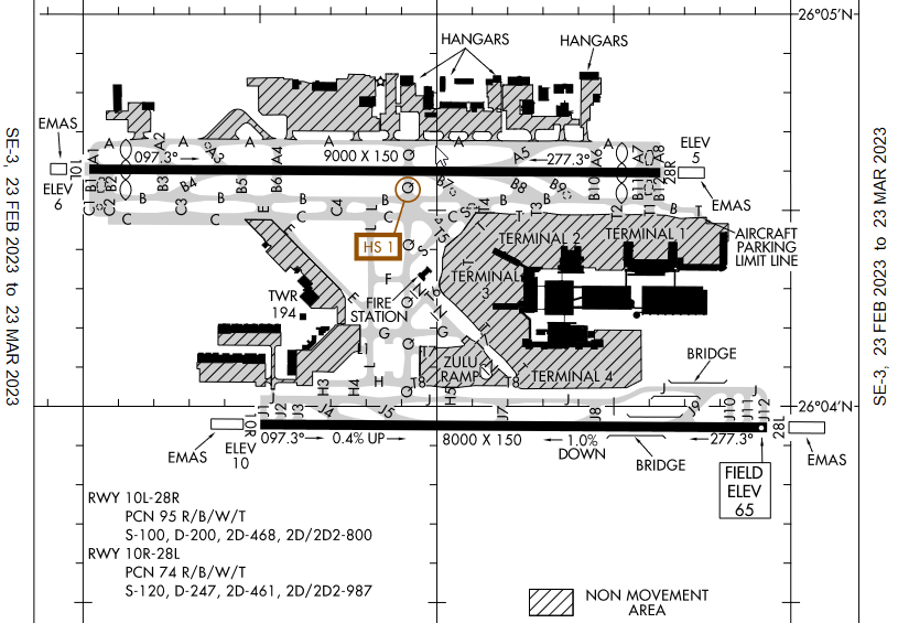
Clearance – At smaller airports, Ground will handle this as well. If you’re flying a flight plan, you need to let ATC know when you’re ready to actually fly it. Flight plans are usually filed in advance. ATC takes those and allocates slots for everyone and adjusts the plans to maximize traffic flow. So, you call them up, they retrieve your plan, and they’ll tell you how they’ve modified your plans. “Clearance, Delta 125 to Atlanta”Ramp – Only at the largest airports. You call them when you’re ready to leave the gate and head for the taxiways. For smaller airports, the ramp is a “non-movement” ie: uncontrolled free-for-all. Sometimes Ground will handle this as a courtesy. “Ramp, American 330 at Gate 31 ready for pushback”Ground – In charge of “movement areas”, usually taxiways. Their #1 job is making sure you don’t get two aircraft nose-to-nose, since most aircraft have no reverse gear. You call them when you’re ready to taxi. “Southwest 444 at [intersection], ready to taxi.” No one, including cars and lawn mowers, does anything in a movement area without getting permission first. See the snip of FLL airport below. Note all of the hashed area is a non-movement (uncontrolled) area.
Tower – In charge of the runways. To a lesser extent, the traffic pattern above the airport. You call them when you’re ready to take off. They’ll then clear you to take off. “JetBlue 660 ready for Departure.”
Departure – Their job is to get you away from the airport and pointed in the right direction and altitude.
Center – Oversee en-route flights. They’ll hand you off to the next sector or Approach

(D)ATIS – You’re going to need to know the weather at the destination airport, and approach gets cranky if you don’t give them the ATIS letter.
Approach – They guide you to the airport and get you into the sequence.
Tower – Will clear you to land
Ground – Clears and gives directions on how to get to parking. Final parking instructions are usually visual, with a Follow Me truck or ramper waving at you.
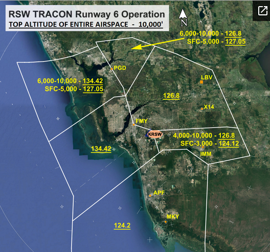
Many airports have multiple frequencies for a particular service, even smaller ones. Here's a map of how multiple approach frequencies work in practice. Note the most NW sector has two different frequencies based on altitude, as that's how the transmitters/antennas are tuned for. These separations are done for technical reasons as well as management reasons. A controller working 124.2 is going to be getting aircraft turned around from whichever direction they're coming from and into the final approach, handing them off to 134.42. A controller managing 134.42 is going to be lining up aircraft for the final approach, one right after another, and handing them off to RSW tower for landing. These frequencies aren't set in stone and change often depending on traffic, technical issues, etc.
The ORD "Z" arrival is a specific instrument approach to do an ILS landing on RWT 10R. It's a very scripted way to get the aircraft lined up and on the ground for that specific runway. I've attached it below.
As far as figuring out which runway a particular aircraft will use isn't straightforward. Typical winds for an area usually determine which runways are preferred, but there are other factors, such as how busy the airport is and ultimately where you're parking at an airport. For example, only certain terminals will have international customs facilities, so it'd make sense to land aircraft on runways near those terminals. Similarly, if you're flying private, the FBO is at the E end of RWY 9C, so it'd make sense to land a smaller plane on one of the RWY 9s rather than RWY 10 and having them taxi forever. You get a feel for what it might be, but there have been plenty of times I got to the destination airport and they gave me a different runway and I'd have to change what I've programmed in.
CTAF: Common Traffic Advisory Frequency. One frequency for all things. You’ll find this most often at airports without a tower (untowered). It’s up to the pilots to sort things out among themselves over the radio to keep from bending metal. Now, towered airports where the tower doesn’t operate 24/7 will also go to CTAF operations when the tower is closed. Usually the normal tower frequency becomes CTAF. For normal operations, here’s the sequence that a pilot would have to handle:
ATIS - Automated Terminal Information System. It’s just a recordingusually updated hourly, of current weather conditions plus relevant airport information, such as which approaches and runways are in use, runway/taxiway closures, and birds in the area. This exists to let the controllers worry about aircraft moving around, not having to read the weather conditions to every single aircraft, tying up the frequencies. Each version of the ATIS will be given a phonetic letter, ie: Alpha, Bravo, Charlie, etc. When you first call up ATC, you’ll let them know which letter you heard, so they know you actually bothered to listen to the recording. D-ATIS is Digital ATIS and shows up on the aircraft’s screen in text form rather than having to listen to the recording.
Clearance – At smaller airports, Ground will handle this as well. If you’re flying a flight plan, you need to let ATC know when you’re ready to actually fly it. Flight plans are usually filed in advance. ATC takes those and allocates slots for everyone and adjusts the plans to maximize traffic flow. So, you call them up, they retrieve your plan, and they’ll tell you how they’ve modified your plans. “Clearance, Delta 125 to Atlanta”Ramp – Only at the largest airports. You call them when you’re ready to leave the gate and head for the taxiways. For smaller airports, the ramp is a “non-movement” ie: uncontrolled free-for-all. Sometimes Ground will handle this as a courtesy. “Ramp, American 330 at Gate 31 ready for pushback”Ground – In charge of “movement areas”, usually taxiways. Their #1 job is making sure you don’t get two aircraft nose-to-nose, since most aircraft have no reverse gear. You call them when you’re ready to taxi. “Southwest 444 at [intersection], ready to taxi.” No one, including cars and lawn mowers, does anything in a movement area without getting permission first. See the snip of FLL airport below. Note all of the hashed area is a non-movement (uncontrolled) area.
Tower – In charge of the runways. To a lesser extent, the traffic pattern above the airport. You call them when you’re ready to take off. They’ll then clear you to take off. “JetBlue 660 ready for Departure.”
Departure – Their job is to get you away from the airport and pointed in the right direction and altitude.
Center – Oversee en-route flights. They’ll hand you off to the next sector or Approach
(D)ATIS – You’re going to need to know the weather at the destination airport, and approach gets cranky if you don’t give them the ATIS letter.
Approach – They guide you to the airport and get you into the sequence.
Tower – Will clear you to land
Ground – Clears and gives directions on how to get to parking. Final parking instructions are usually visual, with a Follow Me truck or ramper waving at you.
- What is meant by the different "facilities" listed? For Approach, for example, it lists NW Feeder, SE Feeder, and W Arrival. I'm assuming the Feeders are for traffic coming in from those directions but what is W Arrival? Traffic seems to tend to arrive from the east.
- Likewise, what is Z arrival?
- What is D-ATIS?
Many airports have multiple frequencies for a particular service, even smaller ones. Here's a map of how multiple approach frequencies work in practice. Note the most NW sector has two different frequencies based on altitude, as that's how the transmitters/antennas are tuned for. These separations are done for technical reasons as well as management reasons. A controller working 124.2 is going to be getting aircraft turned around from whichever direction they're coming from and into the final approach, handing them off to 134.42. A controller managing 134.42 is going to be lining up aircraft for the final approach, one right after another, and handing them off to RSW tower for landing. These frequencies aren't set in stone and change often depending on traffic, technical issues, etc.
The ORD "Z" arrival is a specific instrument approach to do an ILS landing on RWT 10R. It's a very scripted way to get the aircraft lined up and on the ground for that specific runway. I've attached it below.
As far as figuring out which runway a particular aircraft will use isn't straightforward. Typical winds for an area usually determine which runways are preferred, but there are other factors, such as how busy the airport is and ultimately where you're parking at an airport. For example, only certain terminals will have international customs facilities, so it'd make sense to land aircraft on runways near those terminals. Similarly, if you're flying private, the FBO is at the E end of RWY 9C, so it'd make sense to land a smaller plane on one of the RWY 9s rather than RWY 10 and having them taxi forever. You get a feel for what it might be, but there have been plenty of times I got to the destination airport and they gave me a different runway and I'd have to change what I've programmed in.
Last edited by KRSW; Feb 25, 2023 at 12:25 pm
Jan 11, 2024 | 7:56 pm
#7
Join Date: Dec 2001
Location: Boston
Programs: AA ExP, OW Emerald, B6 Mosaic; AA1MM;
Posts: 134
Question: archived ATC for recent go around into CLT?
This thread is very informative Thank you. Reawakening it:
Tuesday I flew BOS to CLT (AA 1453) at close to the peak of the big storm that day- at FL 50' we did a go around (Altitude and big bumps confirmed by the Capt while disembarking). The rest of the story was successful on approach #2 but not without a rodeo. My skills havent been good enough to find the recording of our flight on Live ATC-- Wondering if someone here might lend some tips? Would be informative to hear the sequence of the crew doing what they train to do. No BigJet TV in CLT but there should have been that day!!
Thanks!
Tuesday I flew BOS to CLT (AA 1453) at close to the peak of the big storm that day- at FL 50' we did a go around (Altitude and big bumps confirmed by the Capt while disembarking). The rest of the story was successful on approach #2 but not without a rodeo. My skills havent been good enough to find the recording of our flight on Live ATC-- Wondering if someone here might lend some tips? Would be informative to hear the sequence of the crew doing what they train to do. No BigJet TV in CLT but there should have been that day!!
Thanks!
Jan 14, 2024 | 2:14 pm
#8
FlyerTalk Evangelist


Join Date: Nov 2001
Location: Wanting First. Buying First.
Programs: Lifetime Executive Diamond Platinum VIP with Braniff, Eastern, Midway, National & Pan Am
Posts: 21,962
This thread is very informative Thank you. Reawakening it:
Tuesday I flew BOS to CLT (AA 1453) at close to the peak of the big storm that day- at FL 50' we did a go around (Altitude and big bumps confirmed by the Capt while disembarking). The rest of the story was successful on approach #2 but not without a rodeo. My skills havent been ood enough to find the recording of our flight on Live ATC-- Wondering if someone here might lend some tips? Would be informative to hear the sequence of the crew doing what they train to do. No BigJet TV in CLT but there should have been that day!!
Thanks!
Tuesday I flew BOS to CLT (AA 1453) at close to the peak of the big storm that day- at FL 50' we did a go around (Altitude and big bumps confirmed by the Capt while disembarking). The rest of the story was successful on approach #2 but not without a rodeo. My skills havent been ood enough to find the recording of our flight on Live ATC-- Wondering if someone here might lend some tips? Would be informative to hear the sequence of the crew doing what they train to do. No BigJet TV in CLT but there should have been that day!!
Thanks!
Mind those transition levels/transition altitudes!
With that mini-rant out of the way, look up your BOS-CLT flight on flightaware and find its filed flight plans. Were you on AA1453/09? If so, you filed the CHSLY STAR into CLT:
https://www.flightaware.com/live/fli...410Z/KBOS/KCLT
Go to airnav.com or the FAA's own site, pull the plate for that particular arrival and see that arrivals on the CHSLY STAR will usually initially contact approach on 126.15:
https://aeronav.faa.gov/d-tpp/2313/00078CHSLY.PDF
From there, see if 126.15 is a covered frequency on liveatc.net and its archives. Appears that it is not. All may not be lost though as other CLT approach frequencies are covered by liveatc.net:
https://www.liveatc.net/search/?icao=KCLT
Maybe one of those was working final on the day of your flight. Work backwards from the time you touched down and see.
Generally at large airports like CLT you will be talking to at least two different Approach Control sectors - the initial/feeder controller (126.15) and a final approach controller. Were you at 5000' when you went around you probably were on the final controller's sector.
(Edited to add: Flightaware track log for AA1453/09 shows that the go around was not initiated at 5000'. You hit 1075' on the approach that resulted in a go around. Thus, the go around would certainly have been on the Tower frequency, not approach. Once you've gone around, the handoff from Tower will likely be to a TRACON controller working one of the departures sectors)
Last edited by Herb687; Jan 14, 2024 at 5:20 pm Reason: go around at approx ~1075 ft
 Jan 15, 2024 | 2:39 pm
#9
Original Poster
FlyerTalk Evangelist
Join Date: Nov 2002
Location: ORD
Posts: 14,773
Jan 15, 2024 | 3:35 pm
#10
Join Date: Feb 2002
Location: BNA
Programs: HH Silver. (Former UA PP, DL PM, PC Plat)
Posts: 9,540
Actualy, FL50 is 5,000' (in a standard atmosphere). Add two zeroes. It is not used in the CONUS but is in other parts of the world. Aruba, for example, has a transition altitude of 2,500' and a transition level of FL40.
50,000' would be FL500, in a standard atmosphere.
50,000' would be FL500, in a standard atmosphere.
Jan 15, 2024 | 3:40 pm
#11
Original Poster
FlyerTalk Evangelist
Join Date: Nov 2002
Location: ORD
Posts: 14,773
Sigh. And the bad thing is, I knew that. Brain fart.