


Turbulence Map
 Nov 7, 2016 | 7:45 am
#1
Original Poster
Join Date: Nov 2016
Posts: 3
Turbulence Map
Hello,
Going over JetPlan.com's turbulence forecast map, I am trying to make up what it actually means to the flight.
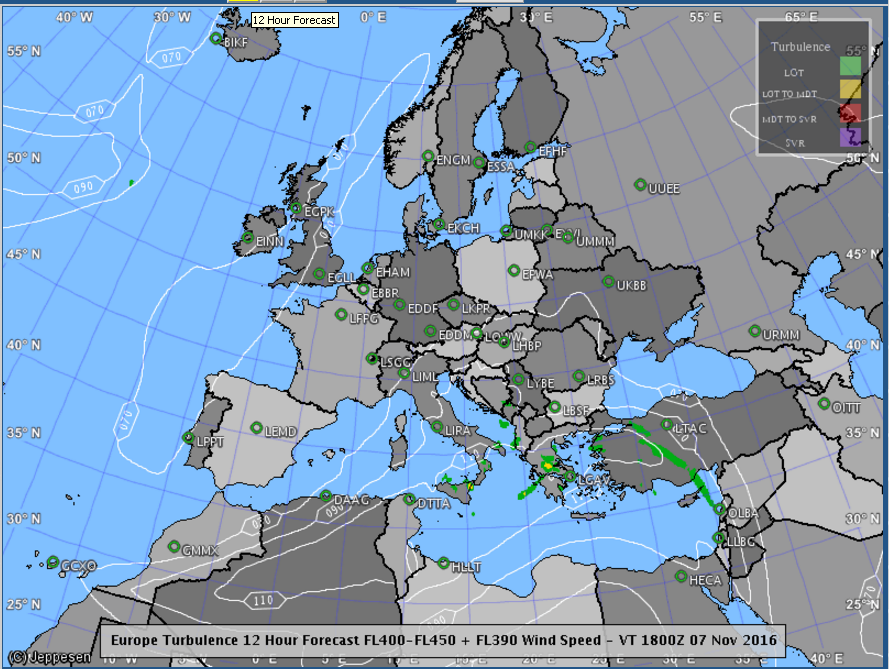
According to the forecast, the first picture looks absolutely smooth all throughout Europe.
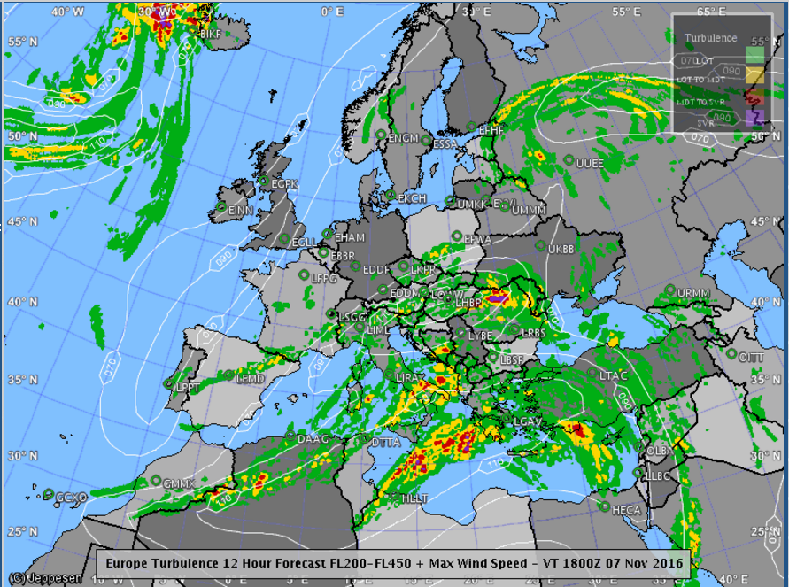
But according to the second picture, and let's say that the forecast is for an altitude of FL300-FL350, on a flight from TLV-FCO, the plane will fly through red, yellow and green. So I'm wondering:
-Does anyone know this map and can tell if that means that the flight will not avoid a moderate turbulence? And a light one?
-Is green (light turbulence) supposed to feel like some bumps only (i.e. water in a cup rippling a bit but no more), or does it feel like more than that?
-Will the pilot bother to bypass a light turbulence or only begin making efforts with a mild one?
Examples:
Thanks very much,
As you can guess this bothers me very much.
Carmel
.
Going over JetPlan.com's turbulence forecast map, I am trying to make up what it actually means to the flight.
According to the forecast, the first picture looks absolutely smooth all throughout Europe.
But according to the second picture, and let's say that the forecast is for an altitude of FL300-FL350, on a flight from TLV-FCO, the plane will fly through red, yellow and green. So I'm wondering:
-Does anyone know this map and can tell if that means that the flight will not avoid a moderate turbulence? And a light one?
-Is green (light turbulence) supposed to feel like some bumps only (i.e. water in a cup rippling a bit but no more), or does it feel like more than that?
-Will the pilot bother to bypass a light turbulence or only begin making efforts with a mild one?
Examples:
Thanks very much,
As you can guess this bothers me very much.
Carmel
.
 Nov 7, 2016 | 8:36 am
#2
In Memoriam, FlyerTalk Evangelist

Join Date: Nov 2002
Location: Southern California
Programs: DL: 3.8 MM, Marriott: Lifetime Titanium
Posts: 24,575
Welcome to FlyerTalk, Carmel10! We hope you find a lot of info that is useful to you in your travels.
We are moving this this thread to a more apropos forum where it is likelier to reach a wider audience. Pls follow at it's new home.
___________________________________
Cholula
CommunityBuzz! Co-Moderator
We are moving this this thread to a more apropos forum where it is likelier to reach a wider audience. Pls follow at it's new home.
___________________________________
Cholula
CommunityBuzz! Co-Moderator
 Nov 7, 2016 | 5:21 pm
#4


Join Date: Oct 2006
Location: IAD
Programs: UA 1K 2MM, Hilton Diamond
Posts: 565
First, that map is a forecast, showing where conditions are favorable for turbulence developing. It doesn't mean it *will* exist. Although I see forecasts in the US for moderate turbulence all the time, it's quite rare that I actually experience it.
Second, the second map you posted is for a huge altitude range - FL200 up to FL450. Within that range, there are likely to be altitudes that are smooth. Most pilots will try to find those. Bouncing around is uncomfortable for them too - makes it difficult to tune radios, write, read, drink coffee, etc. So they will usually do what they can to search for smooth air.
Ultimately, you never really know what you're going to get. Those maps can help, but they are never a guarantee.
Nov 7, 2016 | 7:40 pm
#5
FlyerTalk Evangelist


Join Date: May 2002
Location: Pittsburgh
Programs: MR LT Titanium, AA LT PLT, UA SLV, Avis PreferredPlus, HH Gold, Hertz PC, National Executive, etc.
Posts: 31,670
I don't think flights will make any routing changes based on these forecasts, as they are much less accurate than weather forecasts. And outside of actual severe turbulence reports - in real-time from actual pilots - or severe weather actually occurring, flights will likely just follow the planned route.
I use the US equivalent - http://www.aviationweather.gov/turbulence/gtg - to get a general feel for what might happen, but rely much more on PIREPS - http://www.aviationweather.gov/airep/gis - to see what's actually being reported. To they have the equivalent for Europe?
I use the US equivalent - http://www.aviationweather.gov/turbulence/gtg - to get a general feel for what might happen, but rely much more on PIREPS - http://www.aviationweather.gov/airep/gis - to see what's actually being reported. To they have the equivalent for Europe?
Nov 9, 2016 | 6:01 am
#6
Original Poster
Join Date: Nov 2016
Posts: 3
Hey,
Thank you for the reply!
(I gave the FL200-450 map just as an example for a FL300-350 forecast)
Anyway,
The question comes down really to whether a pilot will change course because of light-moderate turbulence (I can endure a light I guess, but incapable of going through a roller coast-like modeate, and of course, severe),
and, if anyone has experience comparing these forecasts to the actual flight's conditions.
Thanks
Nov 9, 2016 | 7:03 am
#7
Join Date: Jul 2013
Location: DAY/CMH
Programs: UA MileagePlus
Posts: 2,474
The question comes down really to whether a pilot will change course because of light-moderate turbulence (I can endure a light I guess, but incapable of going through a roller coast-like modeate, and of course, severe),
and, if anyone has experience comparing these forecasts to the actual flight's conditions.
and, if anyone has experience comparing these forecasts to the actual flight's conditions.
This article gives a pilot's perspective on the subject.
Nov 9, 2016 | 1:14 pm
#8
FlyerTalk Evangelist
Join Date: May 2002
Location: Pittsburgh
Programs: MR LT Titanium, AA LT PLT, UA SLV, Avis PreferredPlus, HH Gold, Hertz PC, National Executive, etc.
Posts: 31,670
While I agree pilots want to avoid turbulence - the airline won't re-route a flight based on this type of a forecast. It will react to AIRMETS/SIGMETS, and specific PIREPS, but not this model, AFAIK.
Nov 9, 2016 | 2:01 pm
#9
Join Date: Jul 2013
Location: DAY/CMH
Programs: UA MileagePlus
Posts: 2,474
SIGMETS = urgent weather reports for pilots
PIREPS = weather reports from other pilots
The turbulence forecast is not very accurate. Pilots and airlines use much more accurate information to guide their route choices.
Nov 9, 2016 | 3:16 pm
#10

Join Date: Dec 2010
Location: DFW
Programs: UA 1K, AA Platinum, Hilton Diamond, Bonvoy Gold
Posts: 467
I've been flying almost 10 years and can probably count on one hand where the route has changed due to turbulence. For shorter domestic flights it really doesn't make sense. Altitude changes will make a difference though. Once we get to cruising altitude, usually ATC will advise how the rides are based on earlier reports. They'll also suggest smoother altitudes if they know of any. Overseas flights will change flight paths though, but probably more because of winds.