


Flight Paths...
 Dec 10, 2017, 9:07 am
#1
Original Poster
Join Date: Sep 2017
Location: Berkshire / London
Programs: BAEC Gold, Nandos
Posts: 1,009
Who designs flight paths? Each airline or someone else?
I'm interested to why (for example) the LHR-LAS flight path looks like this (super curved).... Is there a science behind it? Is it simply to avoid other flights? How do they decide which flights to lengthen?
Boring Sunday snowed in got my small brain ticking
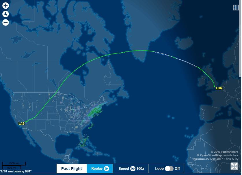
I'm interested to why (for example) the LHR-LAS flight path looks like this (super curved).... Is there a science behind it? Is it simply to avoid other flights? How do they decide which flights to lengthen?
Boring Sunday snowed in got my small brain ticking
 Dec 10, 2017, 9:26 am
#6
Original Poster
Join Date: Sep 2017
Location: Berkshire / London
Programs: BAEC Gold, Nandos
Posts: 1,009
Thanks for replying!
Dec 10, 2017, 9:30 am
#7
Moderator: British Airways Executive Club
Join Date: Jan 2009
Programs: Battleaxe Alliance
Posts: 22,127
Don't feel stupid! It's just to do with difficulties with representing a near-spherical object on a flat surface, which is utterly not your fault* and really, they should draw the rhumb line or something so that it doesn't look like the flight took a very strange curvy path
Dec 10, 2017, 9:32 am
#8
Original Poster
Join Date: Sep 2017
Location: Berkshire / London
Programs: BAEC Gold, Nandos
Posts: 1,009
Don't feel stupid! It's just to do with difficulties with representing a near-spherical object on a flat surface, which is utterly not your fault* and really, they should draw the rhumb line or something so that it doesn't look like the flight took a very strange curvy path
LTN - I then proceeded to read out the question to my family - and the replies from here - and was laughed out of my own house!
Happy Sunday, all!
Dec 10, 2017, 9:36 am
#9
Join Date: Jun 2017
Programs: Entry Level Expert
Posts: 16
There's a society for people like you 
Honestly, don't feel daft. I didn't understand it without explanation at first. When I was younger and first flew UK - US via AMS, I didn't get why we flew down to then fly all the way back up over where we'd just come from. Obviously that was also to do with flight availability and price, but still..
Honestly, don't feel daft. I didn't understand it without explanation at first. When I was younger and first flew UK - US via AMS, I didn't get why we flew down to then fly all the way back up over where we'd just come from. Obviously that was also to do with flight availability and price, but still..
Dec 10, 2017, 9:38 am
#10
Join Date: Oct 2015
Location: Up North.
Programs: BAEC Silver
Posts: 311
Bit of a long read but this is interesting: https://nats.aero/blog/2014/06/north...ateway-europe/
NATS basically design 'tracks' each day depending on the jetstream. Each aircraft then gets assigned a track.
NATS basically design 'tracks' each day depending on the jetstream. Each aircraft then gets assigned a track.
Dec 10, 2017, 10:56 am
#12
Join Date: Oct 2016
Posts: 698
One other factor about this route is that it passed through Canadian airspace. Canadian airspace is more expensive to travel through than, say, US airspace (in some cases).
The slight flattening of the curve between the Canadian border and LAS may (or may not) account for this. What I mean is that the route has been slightly altered to minimise time over Canada.
The slight flattening of the curve between the Canadian border and LAS may (or may not) account for this. What I mean is that the route has been slightly altered to minimise time over Canada.
Dec 10, 2017, 12:27 pm
#13
Join Date: Dec 2016
Location: WAW
Programs: A3(*G), Marriott Platinum, Hilton Diamond, IHG Diamond Ambassador
Posts: 2,534
I was going to post about how this route is not simply a great circle as it has a deviation to cut down on overflight fees generated by flying across Canada. Then I saw MarkFlies post above and realised he'd beat me to it.
Flights from SFO, LAX, etc. will often take a more easterly track to reduce the total cost. The airlines have sophisticated software tools that allow them to plug in all the various parameters (flight time, fuel burn, jetstream/weather conditions, overflight costs, ...) in order to map out an optimal route according to the anticipated conditions for the flight.
This video from Wendover Productions has more info on this (starting from around 4:25):
Dec 10, 2017, 12:55 pm
#14
Join Date: Nov 2004
Location: LHR GVA HKG TLV PVG JFK
Programs: AA EXP
Posts: 3,952
These "spherical Earther" weirdos are like a cult. If the the earth was spherical then to get to the other side of earth all you needed to do was take off, fly circuits in place and the rotation of the earth would bring you to the other side. Well we know that does not work like this, you actually have to fly somewhere to get there.
Cmon you spherical earthers. Proven science is above, weird theories...
Cmon you spherical earthers. Proven science is above, weird theories...
Dec 10, 2017, 1:42 pm
#15
Join Date: Nov 2010
Posts: 5,596
Some airlines have their own flight planning computer time,others use bought in service.Normal parameters for a route being chosen include winds,airspace closures,overflight charges,insurance and crew costs,aircraft weight and a number of other factors.The numbers are crunched by high speed computers and usually 2 or 3 options are added with costs and fuel burn.For a B747 fuel burn is worked to the nearest 50 or 100 Kgs out of a possible 160 tonnes or so.
Like most things in aviation it is worked to minimum cost.
Like most things in aviation it is worked to minimum cost.