






















Cambodia - Thai Border Temples
 Jul 8, 2019 | 2:26 pm
#16
Original Poster


Join Date: Jul 2001
Location: Berkeley, CA USA
Programs: Kam Leng; Two Dragons GH
Posts: 1,615
Based on a June, 2019 visit, on the Cambodian side you just walk up to the temple.
The furnicular, if it still exists, must be on the Thai side. No Thais, tourists or soldiers, on my visit.
The furnicular, if it still exists, must be on the Thai side. No Thais, tourists or soldiers, on my visit.
 Jul 8, 2019 | 6:17 pm
#17
Original Poster
Join Date: Jul 2001
Location: Berkeley, CA USA
Programs: Kam Leng; Two Dragons GH
Posts: 1,615
This is a follow on to my previous, now years old post about Angkor era border temples.
Overview
While major Angkor era sites near Siem Reap are showing all the signs of overtourism, there are several where it’s rare to see a foreigner. Farther afield, in the north west, near the Thai-Cambodian border, it’s even less likely to see anyone but local people, soldiers, or a demining team.
In June, 2019 on three separate days I went with a longtime Khmer friend/guide/driver to ten sites, major and minor, where we encountered a total of one foreigner.
This is a short report on three approachable border sites that can be done as a day trip from Siem Reap.
Prasat Khnar
Prasat Khnar is the easternmost of these sites. It’s about 2-3 hours from Siem Reap on generally good roads, some of which aren’t marked on Google Maps. Signage is poor making navigation a bit of a challenge. I’ve included GPS coordinates for some key waypoints.
Start by going from Siem Reap to the town of Samraong, then at the north west end of Independence Park, at GPS 14.190443, 103.503478, take the road that goes north.
The provincial tourism office is close by, though limited English is spoken. Lodging, if needed; ok toilet; and local restaurant area are at Silver Wood hotel. A new hotel/guesthousel is Thinny Guesthouse, which I didn’t inspect. Hotels are currently US15/night, no breakfast.
The road north from Samraong is dirt and might be an issue in the rainy season, though we didn’t have a problem when we used it in dry conditions. Google Maps map view shows the road as discontinuous, but satellite view shows it correctly as continuous.
Continue on the north road until it intersects an east-west sealed road at GPS 14.362637, 103.507947. “You can’t miss it,” but there should be a road marker across the road showing “243.”

Distance marker at intersection from Samraong to Prasat Khnar
Turn left onto the sealed road.
Continue west until a dirt road turnoff to the north at 14.353878, 103.458967. Google Maps may have this as Prasat Khnar turnoff.

Prasat Khnar turnoff
Continue north to the dead end, 14.361971, 103.457862. This area may be depicted on Google Maps as Parking for stairs to Prasat Khnar. Parking is free, with a simple shelter from the sun.
From the parking lot, continue north on the evident path to the foot of the wooden stairs.

Prasat Khnar stairs
From the bottom to the top of the 1000+ stairs takes about 30 minutes at a steady pace. It’s mostly in the shade.
Once at the top head east along the obvious path that’s been marked as cleared of mines. After about 1km you are rewarded by, actually, not much, just some wall remnants and some salvaged stones piled up by local people, as well as a vantage point over the Cambodian plain. There’s no real evidence of archaeological conservatorship.

Prasat Khnar vista over Cambodian plain

Prasat Khnar ruins

Prasat Khnar ruins
Paths in this area aren’t marked as cleared of mines, but seemed ok. I wouldn’t go off the well used paths.
We spent about 20 minutes at the top before heading down past active mine clearing operations. My guide felt it was appropriate to give US$5 to one of the soldiers who showed us the best path.
Prasat Ta Krabey
Approximately 25km by road away from Prasat Khnar parking is parking for Prasat Ta Krabei at 14.351885, 103.374230.
Head west from Prasat Khnar on the sealed road to the traffic circle at 14.351885, 103.374230, then take the exit to the north, which goes up a hill on a concrete road.
After 500m, at 14.341472, 103.305804, you’ll see an unsigned turnoff, though with a Cambodian government marker in Khmer script only, that starts as a short, 50m stretch of dirt road, and then becomes concrete.
Approximately 7.7km to the east there’s turnoff north at 14.350495, 103.374516, which is signed.

Prasat Ta Krabei turnoff
Approximately 180m up the dirt road is parking at 14.351853, 103.374231.
There’s a clear path up the hill for approximately 100m to the temple site. There’s a good chance you’ll be accompanied by unarmed Khmer soldiers.
The small site is quite nice and can be visited in 20 minutes, perhaps less.

Prasat Ta Krabei
The soldiers have informally marked the Thai-Cambodia border.

Prasat Ta Krabei rustic border marker
On our visit there were no Thai soldiers, but apparently in the evenings Thai and Khmer soldiers eat dinner together and share this shelter.

Prasat Ta Krabei soldiers' shelter
On leaving we gave US$10 to the Khmer soldiers, though they didn’t ask for anything. My guide said it was to thank them for preserving the site, not just from Thai soldiers, but also from tomb robbers.
Prasat Ta Moan Thom
Approximately 14.8km to the west along good roads is parking, at 14.343950, 103.264756, for the Prasat Ta Moen complex, only one temple of which is accessible from the Cambodian side.
From the parking site you can walk, but it’s quite steep and we hired motos with drivers for US$5 for each person for the round trip, including waiting time. The motos let you out at a barrier that’s still 300m or so walking distance from the Ta Moen site.
The site is really worth visiting.
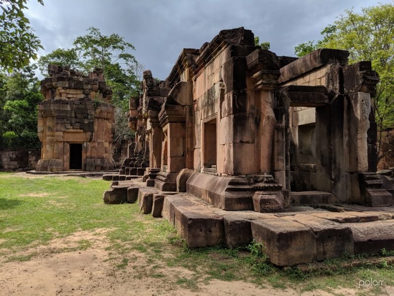
Prasat Ta Moan Thom
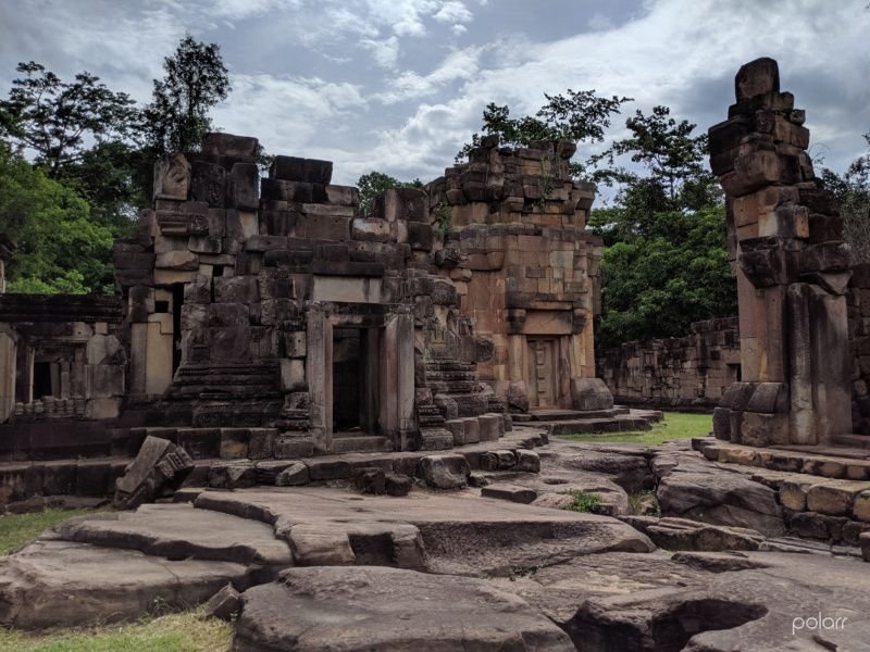
Prasat Ta Moan Thom
Unarmed Thai and Khmer soldiers were at the site on our visit and seemed to be friendly to each other and to visitors. We didn’t pay any soldiers at this site. We spent about 30 minutes here.
There are two minor sites down the road on the Thai side that are worth visiting, but were inaccessible on our visit from the Cambodian side, Prasat Ta Muean Tot (Arokayasala) and Prasat Ta Muean. They can be accessed from the Thai town of Nang Rong as a day trip, though perhaps there’s easier access.
Practicalities
These sites can be visited as a day trip from Siem Reap, though dirt roads may be difficult after prolonged rain.
There was no apparent UXO (unexploded ordnance) hazard on our visit, though we were careful to stay to worn paths and marked, cleared paths in the case of Prasat Khnar.
The stairs leading to Prasat Khnar require a certain amount of fitness. Access to Prasat Ta Krabei is fairly easy. Access to the Ta Moen site require the ability to be a passenger on a moto up a steep hill or walking up and down the hill.
There are no formal admission charges and Angkor Archaeological Park tickets aren’t required.
Toilet facilities at the sites are rustic at best. No food or water vendors at the sites.
-end-
Overview
While major Angkor era sites near Siem Reap are showing all the signs of overtourism, there are several where it’s rare to see a foreigner. Farther afield, in the north west, near the Thai-Cambodian border, it’s even less likely to see anyone but local people, soldiers, or a demining team.
In June, 2019 on three separate days I went with a longtime Khmer friend/guide/driver to ten sites, major and minor, where we encountered a total of one foreigner.
This is a short report on three approachable border sites that can be done as a day trip from Siem Reap.
Prasat Khnar
Prasat Khnar is the easternmost of these sites. It’s about 2-3 hours from Siem Reap on generally good roads, some of which aren’t marked on Google Maps. Signage is poor making navigation a bit of a challenge. I’ve included GPS coordinates for some key waypoints.
Start by going from Siem Reap to the town of Samraong, then at the north west end of Independence Park, at GPS 14.190443, 103.503478, take the road that goes north.
The provincial tourism office is close by, though limited English is spoken. Lodging, if needed; ok toilet; and local restaurant area are at Silver Wood hotel. A new hotel/guesthousel is Thinny Guesthouse, which I didn’t inspect. Hotels are currently US15/night, no breakfast.
The road north from Samraong is dirt and might be an issue in the rainy season, though we didn’t have a problem when we used it in dry conditions. Google Maps map view shows the road as discontinuous, but satellite view shows it correctly as continuous.
Continue on the north road until it intersects an east-west sealed road at GPS 14.362637, 103.507947. “You can’t miss it,” but there should be a road marker across the road showing “243.”
Distance marker at intersection from Samraong to Prasat Khnar
Turn left onto the sealed road.
Continue west until a dirt road turnoff to the north at 14.353878, 103.458967. Google Maps may have this as Prasat Khnar turnoff.
Prasat Khnar turnoff
Continue north to the dead end, 14.361971, 103.457862. This area may be depicted on Google Maps as Parking for stairs to Prasat Khnar. Parking is free, with a simple shelter from the sun.
From the parking lot, continue north on the evident path to the foot of the wooden stairs.
Prasat Khnar stairs
From the bottom to the top of the 1000+ stairs takes about 30 minutes at a steady pace. It’s mostly in the shade.
Once at the top head east along the obvious path that’s been marked as cleared of mines. After about 1km you are rewarded by, actually, not much, just some wall remnants and some salvaged stones piled up by local people, as well as a vantage point over the Cambodian plain. There’s no real evidence of archaeological conservatorship.
Prasat Khnar vista over Cambodian plain
Prasat Khnar ruins
Prasat Khnar ruins
Paths in this area aren’t marked as cleared of mines, but seemed ok. I wouldn’t go off the well used paths.
We spent about 20 minutes at the top before heading down past active mine clearing operations. My guide felt it was appropriate to give US$5 to one of the soldiers who showed us the best path.
Prasat Ta Krabey
Approximately 25km by road away from Prasat Khnar parking is parking for Prasat Ta Krabei at 14.351885, 103.374230.
Head west from Prasat Khnar on the sealed road to the traffic circle at 14.351885, 103.374230, then take the exit to the north, which goes up a hill on a concrete road.
After 500m, at 14.341472, 103.305804, you’ll see an unsigned turnoff, though with a Cambodian government marker in Khmer script only, that starts as a short, 50m stretch of dirt road, and then becomes concrete.
Approximately 7.7km to the east there’s turnoff north at 14.350495, 103.374516, which is signed.
Prasat Ta Krabei turnoff
Approximately 180m up the dirt road is parking at 14.351853, 103.374231.
There’s a clear path up the hill for approximately 100m to the temple site. There’s a good chance you’ll be accompanied by unarmed Khmer soldiers.
The small site is quite nice and can be visited in 20 minutes, perhaps less.
Prasat Ta Krabei
The soldiers have informally marked the Thai-Cambodia border.
Prasat Ta Krabei rustic border marker
On our visit there were no Thai soldiers, but apparently in the evenings Thai and Khmer soldiers eat dinner together and share this shelter.
Prasat Ta Krabei soldiers' shelter
On leaving we gave US$10 to the Khmer soldiers, though they didn’t ask for anything. My guide said it was to thank them for preserving the site, not just from Thai soldiers, but also from tomb robbers.
Prasat Ta Moan Thom
Approximately 14.8km to the west along good roads is parking, at 14.343950, 103.264756, for the Prasat Ta Moen complex, only one temple of which is accessible from the Cambodian side.
From the parking site you can walk, but it’s quite steep and we hired motos with drivers for US$5 for each person for the round trip, including waiting time. The motos let you out at a barrier that’s still 300m or so walking distance from the Ta Moen site.
The site is really worth visiting.
Prasat Ta Moan Thom
Prasat Ta Moan Thom
Unarmed Thai and Khmer soldiers were at the site on our visit and seemed to be friendly to each other and to visitors. We didn’t pay any soldiers at this site. We spent about 30 minutes here.
There are two minor sites down the road on the Thai side that are worth visiting, but were inaccessible on our visit from the Cambodian side, Prasat Ta Muean Tot (Arokayasala) and Prasat Ta Muean. They can be accessed from the Thai town of Nang Rong as a day trip, though perhaps there’s easier access.
Practicalities
These sites can be visited as a day trip from Siem Reap, though dirt roads may be difficult after prolonged rain.
There was no apparent UXO (unexploded ordnance) hazard on our visit, though we were careful to stay to worn paths and marked, cleared paths in the case of Prasat Khnar.
The stairs leading to Prasat Khnar require a certain amount of fitness. Access to Prasat Ta Krabei is fairly easy. Access to the Ta Moen site require the ability to be a passenger on a moto up a steep hill or walking up and down the hill.
There are no formal admission charges and Angkor Archaeological Park tickets aren’t required.
Toilet facilities at the sites are rustic at best. No food or water vendors at the sites.
-end-