This post is sort of an addendum to post 13 because I've optimized my trail logistics quite a bit over the past several months, and I'd like to offer my opinions on logical start/end subway stations near the bike trail. So, I've reannotated the exploreshanghai map here (you can see the complete map at
https://exploreshanghai.com/metro/#). Obviously, it's not to scale, but I'm using it here because baidu and amap are too cluttered for this purpose and google/maps.me aren't up to speed with the newest subway lines.
I've also mentioned that taking ferries across the river also works, and if you're new to Shanghai, I certainly recommend trying at least one ferry (they only take around 3 minutes to cross the river and you'll be able to snap some cool pics). However, you need to get to the river in order to use them, which is often inefficient.
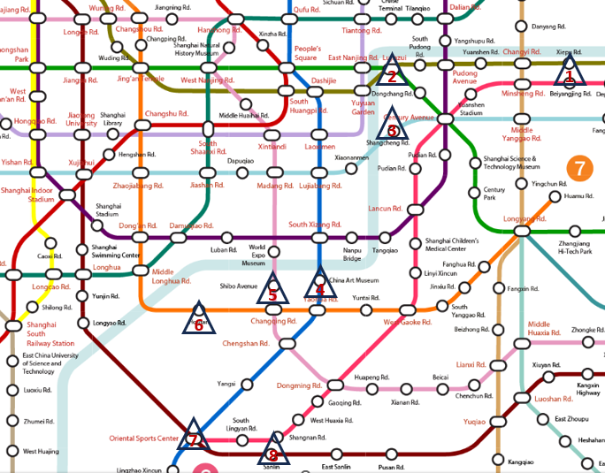
Cutting to the chase, the following are comments on subway stations near the bike trail that I have used myself in order to access the trail (I haven't tried them all yet, and I'm not sure I'll get around to Tangqiao on Line 4 even though it seems close because I rarely take line 4).
1. Xiepu Rd (Line 14). This station is among the most convenient wrt trail access and it happens to be nestled up against the Yangpu Bridge, which is the northern terminus. Furthermore, line 14 is really nice and fast (I don't think it actually travels faster than other lines, but the stations are kind of far apart). In any event, if I had to rank all 8 options, Xiepu Rd would be on the top of my list, without question. Use exit 4.
2. Luijiazui (Lines 2 and 14). I can only recommend Lujiazui as a start/end point if you are actually doing activities in Lujiazui (e.g. aquarium, pearl tower, Flair, or any of the restaurants in Binjiang Park). You'll want go between the subway station and the river on foot because traffic can be insane and confusing.
3. Shangcheng Rd (Line 9). I use this one sometimes because line 9 is convenient for me, and on weekends I often start at the south end and escape at Shangcheng Rd because Binjiang Park and points north is extremely slow going. It's a little less than 1 km from the trail.
4 and 5. China Art Museum (Line 8) and Shibo Ave (Line 13). I'm grouping these together because they are essentially in the same place wrt the trail (Mercedes Benz Arena). They are both pretty close to the river, as the crow flies, but you'll need to hunt for good access points in this area. This is essentially the halfway point (13 km from the top).
6. Houtan (Line 7). Houtan is the second most convenient wrt trail subway station I have used, and it's an excellent start/end point because chopping off the bottom ~6 km isn't the end of the world. The subway station is easy to spot because it's basically underneath the SK building.
7. Oriental Sports Center (Line 11). This is the closest line 11 stop to the river on the east side, and it's actually not that close (about 1 km). I start my rides there whenever I don't feel like including the very bottom 2 km (plus Sanlin).
8. Sanlin (Line 11). This is one stop after Oriental Sports Center and 4 km from the river, but the ride from there to the trail is almost as civilized as the trail itself (e.g. dedicated bike lane and very few delivery drivers), and it dumps you at the very bottom (I think the trail will be extended in the future, but the Xupu Bridge is the current terminus).
.