


Seattle Snowpocalypse Feb 8-12 2019 Megathread
 Feb 6, 2019, 3:38 pm
#1
Original Poster
Join Date: May 2009
Location: Seattle, WA
Programs: DL Diamond 1.7MM, Starlux Insighter, Bonvoy Titanium, Hilton Gold, Hertz PC
Posts: 3,947
Seattle Snowpocalypse Feb 8-12 2019 Megathread
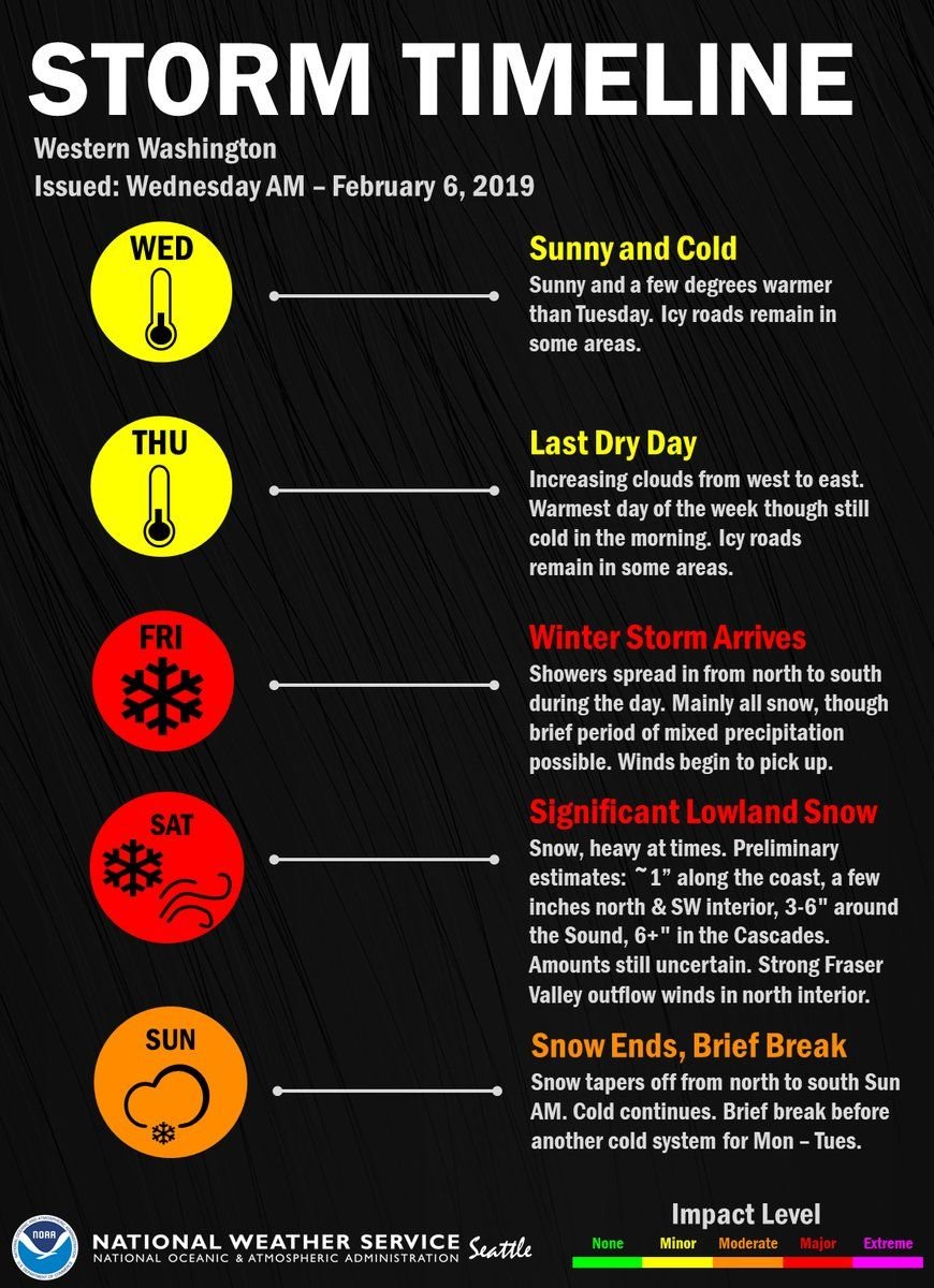
Thought I'd start a thread here on FT to cover some of the water cooler conversation that's happening here in town, because forecasts are starting to point to a major weather event this weekend that's likely to impact Seattle-Tacoma travel well into next week.
Essentially, on top of the snow we've already received this week, Seattle is destined for two more snowstorms: one Friday night into Sunday morning that could drop ~3-6" of snow, and another one Monday-Tuesday that will add another 3-6". At the worst, we could be in for over a foot of snow - there are a few models that predict even higher accumulation amounts around Puget Sound (with the European model predicting up to 20" total.)
The hyperbole in the thread title will almost certainly prompt a heartily deserved eyeroll from our friends in MSP and DTW, but Seattle almost never sees this much snow - less than once per decade. We simply don't have the snow removal equipment to handle it, and combined with all the hills in town, an event like this will shut down the city for multiple days. That will likely extend to the airport, as well - the last snow event caused major cancellations at SEA, and it was much less severe than this one is being predicted to be.
Some discussion from local weather sources:
- Cliff Mass (a respected, if a bit hyperbolic, local forecaster/professor/weather blogger) (current prediction 6in Fri-Sat + 6in Mon-Tue)
- KOMO TV (current prediction 3-6 in Fri-Sat + slightly less 2-5 in Tuesday)
- Weather Underground (prediction 4-8 in Fri-Sat + 5-8 in Monday)
- European ECMWF Model (prediction 6-8 in Fri-Sat + 8 to 12 in Monday-Tuesday)
We're still too far out for weather waivers to be issued yet - predicting snow around here is famously sketchy - but the models are starting to converge, and if you're planning travel to or through SEA in this timeframe it's probably time to start thinking about alternatives. If you're planning work travel here early next week, it's likely your colleagues won't be in the office and the whole city will be shut down for a "work from home" day (translation: hot chocolate and sledding). If you're simply connecting, I expect the airport will probably recover within 24 hours of each precipitation event stopping, but as long as the snow is falling it's going to be ugly, and cold temperatures could mean heavy deicing delays that aren't planned into the schedule like they would be in other stations. The view of Mt. Rainier from the A SkyClub sure will be pretty, though!
I'll try to post new information as we get it, and would encourage others to as well. I suspect we'll get a weather waiver sometime tomorrow afternoon once the forecast firms up, and by then hopefully the impact will be a little more clear of the storm.
(Of course, this snow event could turn out to be nothing, in which case I'll cheerfully accept a mocking thread title change by the mods and slink back to the Lounge thread where I belong. )
)
Essentially, on top of the snow we've already received this week, Seattle is destined for two more snowstorms: one Friday night into Sunday morning that could drop ~3-6" of snow, and another one Monday-Tuesday that will add another 3-6". At the worst, we could be in for over a foot of snow - there are a few models that predict even higher accumulation amounts around Puget Sound (with the European model predicting up to 20" total.)
The hyperbole in the thread title will almost certainly prompt a heartily deserved eyeroll from our friends in MSP and DTW, but Seattle almost never sees this much snow - less than once per decade. We simply don't have the snow removal equipment to handle it, and combined with all the hills in town, an event like this will shut down the city for multiple days. That will likely extend to the airport, as well - the last snow event caused major cancellations at SEA, and it was much less severe than this one is being predicted to be.
Some discussion from local weather sources:
- Cliff Mass (a respected, if a bit hyperbolic, local forecaster/professor/weather blogger) (current prediction 6in Fri-Sat + 6in Mon-Tue)
- KOMO TV (current prediction 3-6 in Fri-Sat + slightly less 2-5 in Tuesday)
- Weather Underground (prediction 4-8 in Fri-Sat + 5-8 in Monday)
- European ECMWF Model (prediction 6-8 in Fri-Sat + 8 to 12 in Monday-Tuesday)
We're still too far out for weather waivers to be issued yet - predicting snow around here is famously sketchy - but the models are starting to converge, and if you're planning travel to or through SEA in this timeframe it's probably time to start thinking about alternatives. If you're planning work travel here early next week, it's likely your colleagues won't be in the office and the whole city will be shut down for a "work from home" day (translation: hot chocolate and sledding). If you're simply connecting, I expect the airport will probably recover within 24 hours of each precipitation event stopping, but as long as the snow is falling it's going to be ugly, and cold temperatures could mean heavy deicing delays that aren't planned into the schedule like they would be in other stations. The view of Mt. Rainier from the A SkyClub sure will be pretty, though!
I'll try to post new information as we get it, and would encourage others to as well. I suspect we'll get a weather waiver sometime tomorrow afternoon once the forecast firms up, and by then hopefully the impact will be a little more clear of the storm.
(Of course, this snow event could turn out to be nothing, in which case I'll cheerfully accept a mocking thread title change by the mods and slink back to the Lounge thread where I belong.
)
 Feb 6, 2019, 5:10 pm
#2
Join Date: Aug 2018
Location: SEA
Programs: DL DM
Posts: 292
The few inches that arrived on Sunday basically shut down my office in downtown Seattle for 2 days..
If this arrives as-is, it reminds me of the snow event maybe 5-6 years ago that shut down everything for almost a week.
If this arrives as-is, it reminds me of the snow event maybe 5-6 years ago that shut down everything for almost a week.
Feb 6, 2019, 5:50 pm
#6
FlyerTalk Evangelist
Join Date: Jun 2001
Programs: DL 1 million, AA 1 mil, HH lapsed Diamond, Marriott Plat
Posts: 28,190
After conferring with another DL forum Mod, this thread is going to the PNW Destinations forum.
Were one to be a little competitive and compare DL/DL Connection cancellations over the period to AS/QX cancellations, that would be fairly DL-related.
3Cforme - Delta Forum Moderator
Were one to be a little competitive and compare DL/DL Connection cancellations over the period to AS/QX cancellations, that would be fairly DL-related.
3Cforme - Delta Forum Moderator
Feb 6, 2019, 6:30 pm
#7
Join Date: Jan 2017
Location: Denver
Programs: AS, AA, UA, Hilton, Marriott, Caesars DE
Posts: 2,070
Feb 6, 2019, 6:33 pm
#8
Join Date: Apr 2011
Location: Treasure Coast, FL
Programs: DL Diamond, Marriott LT Plat, HH Diamond, Avis Preferred Plus, National Executive
Posts: 4,578
Was just about to post about 2008. I was in PDX (Vancouver, WA to be exact) and it was a lot of snow over multiple days. Think the total in our area was close to 14" and there was an ice storm mixed in the middle of it all. CIty was shut down for a few days.
Here is a link to the storm:
https://expo.oregonlive.com/news/err...08-blizza.html
Here is a link to the storm:
https://expo.oregonlive.com/news/err...08-blizza.html
Feb 6, 2019, 8:10 pm
#10
FlyerTalk Evangelist


Join Date: Jun 2010
Location: TOA
Programs: HH Diamond, Marriott LTPP/Platinum Premier, Hyatt Lame-ist, UA !K
Posts: 20,061
Feb 6, 2019, 8:46 pm
#11
Join Date: Aug 2015
Location: SEA
Programs: Alaska Airlines MVP Gold
Posts: 301
There's an interesting article about it on Ars Technica
https://arstechnica.com/science/2016/03/the-european-forecast-model-already-kicking-americas-butt-just-improved/
Feb 6, 2019, 10:25 pm
#12
Join Date: Mar 2015
Location: SEA
Programs: AS MVP , Delta Gold Medallion, "Credit Card" status for various hotels
Posts: 672
Yes - the snowstorm in Seattle this past Sun/Mon was accurately predicted by the European model (it called for 4�) while the other models predicted an inch or less.
 Feb 7, 2019, 9:47 am
#13
Original Poster
Join Date: May 2009
Location: Seattle, WA
Programs: DL Diamond 1.7MM, Starlux Insighter, Bonvoy Titanium, Hilton Gold, Hertz PC
Posts: 3,947
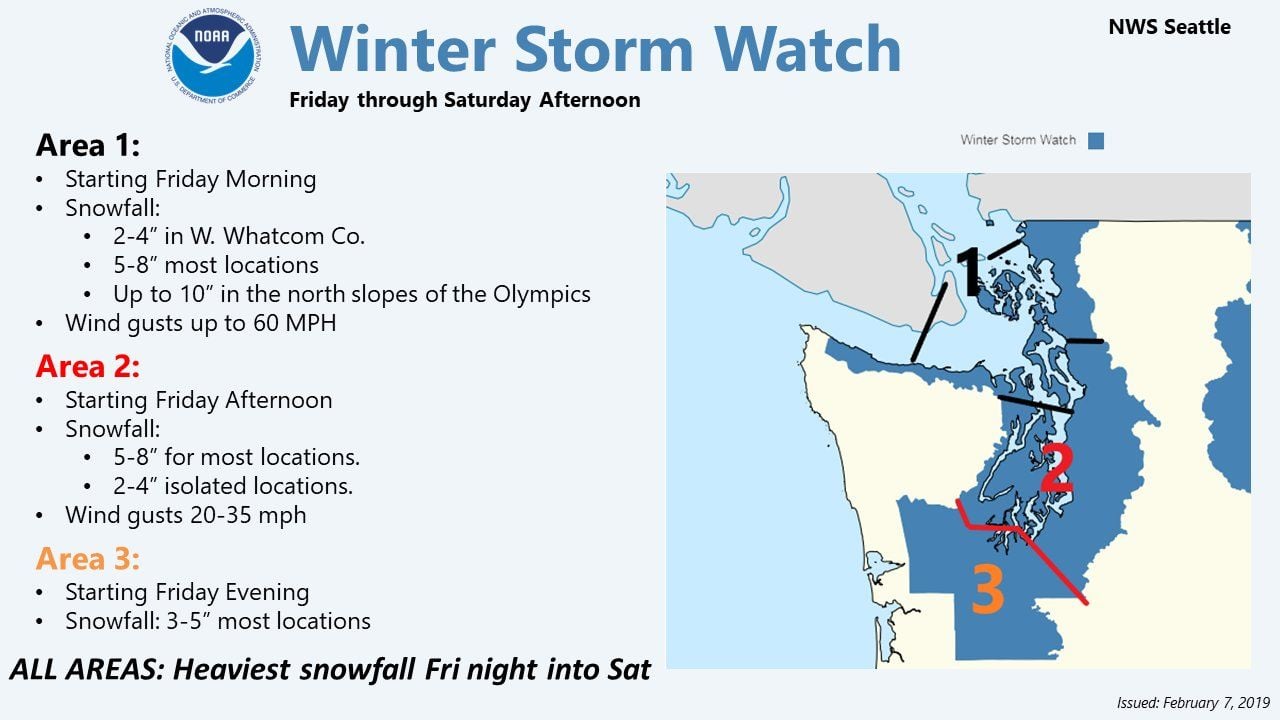
So far, seems like at least the first storm is still on track. The National Weather Service is upgrading its prediction and now the guess for Puget Sound is closer to 5-8 inches in the first (Fri-Sat) event:
Feb 7, 2019, 4:45 pm
#14
Original Poster
Join Date: May 2009
Location: Seattle, WA
Programs: DL Diamond 1.7MM, Starlux Insighter, Bonvoy Titanium, Hilton Gold, Hertz PC
Posts: 3,947
[moderator edit] the weather waiver is now out right on schedule from Delta for the first, more certain snow event. It covers flights on Friday and Saturday, but not Sunday or beyond yet:
https://www.delta.com/us/en/advisori...winter-weather
https://www.delta.com/us/en/advisori...winter-weather
Last edited by NewbieRunner; Feb 7, 2019 at 10:39 pm Reason: Redacted comment on moderation
Feb 7, 2019, 5:26 pm
#15
Join Date: Jan 2017
Location: Denver
Programs: AS, AA, UA, Hilton, Marriott, Caesars DE
Posts: 2,070