


The BA Cloud!

 May 27, 2012, 12:14 pm
#47
Original Poster


Join Date: Nov 2010
Location: Bristol, UK
Programs: HH D, Rad Plat
Posts: 5,352
Brilliant pictures BBB ^
Can't resist commenting on at least some of them...
A great, but scary photo Do you remember how the weather developed after that? Curious if it was just threatening or if you had any thunderstorms / worse!
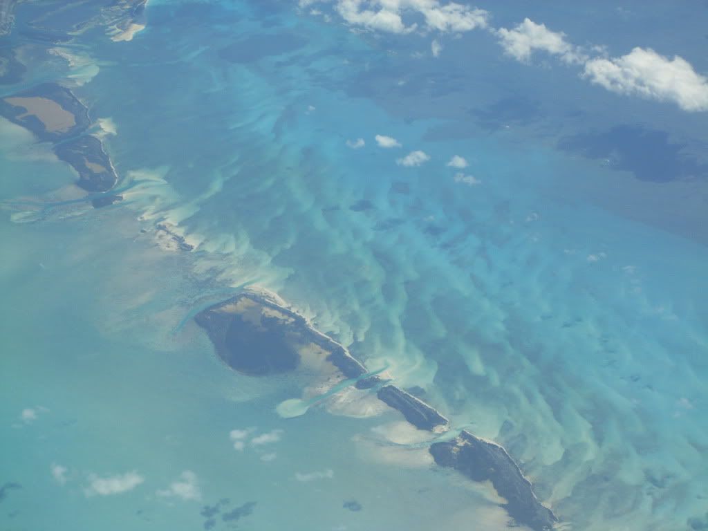
Lovely scenery! A good example of how little 'lift' is needed to develop cloud in such warm, hot environments...these are not threatening yet though...friendly little fellows...
Ooh, I want one...
Good thing I wasn't flying...I would have been porpoising in and out of those cloud tops, screaming like a kid at a water park!
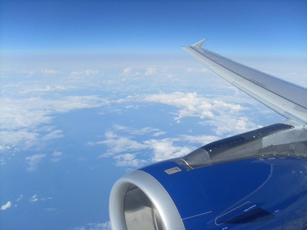
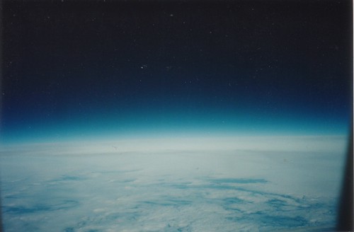
An excellent example of the boundary layer...you can clearly see the change in colour and an almost clearly defined line where the sky becomes a nice clean blue and below that a bit fuzzy grey tinge to it....this is where the winds are still producing a turbulent flow and causing some pollution, particles, cloud, etc...but above that...nice and smooth...Very nice!
Hope to see more if you get the chance once in a while between other things with the new long haul flights ^
Can't resist commenting on at least some of them...
A great, but scary photo
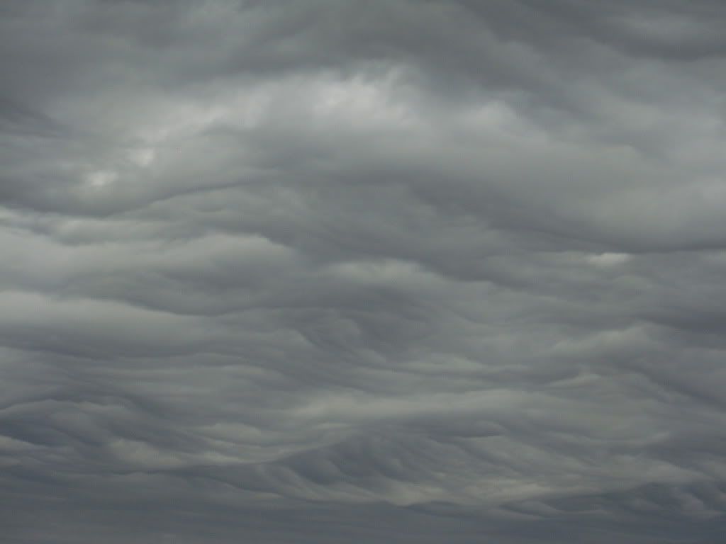 Do you remember how the weather developed after that? Curious if it was just threatening or if you had any thunderstorms / worse!
Somewhere over the Gulf of Mexico on the way to Nicaragua:
From an A320 flight deck, somewhere... :
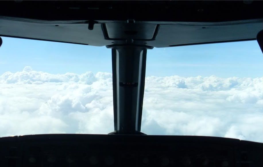
Good thing I wasn't flying...I would have been porpoising in and out of those cloud tops, screaming like a kid at a water park!
Another one taken on the way to somewhere... Can't remember where:
Hope to see more if you get the chance once in a while between other things with the new long haul flights ^
May 27, 2012, 3:17 pm
#48
FlyerTalk Evangelist
Join Date: Mar 2010
Location: JER
Programs: BA Gold/OWE, several MUCCI, and assorted Pensions!
Posts: 32,144
May 27, 2012, 3:32 pm
#49
FlyerTalk Evangelist
Join Date: Nov 2007
Location: The Hague, NL
Programs: GMLFL, Life 2.0 - Mucci Premiere Classe & des Chevaliers Toulousiens
Posts: 22,911
Loving the pictures and the explanations. BBB's pic from Ogunquit looks impressive indeed.
Here are my contributions for the day...


Sorry, got carried away...
Here are my contributions for the day...
Sorry, got carried away...
Last edited by henkybaby; May 27, 2012 at 4:12 pm
May 27, 2012, 3:40 pm
#50
FlyerTalk Evangelist
Join Date: Dec 2008
Location: Home: East Mids UK - Work (Base): Accra, Ghana.
Programs: BAEC: Silver - Marriott: Titanium
Posts: 12,086
Why thank you!
Yes... We had a big, but not very long storm after that with very heavy rain. To the point where the friend was instructed to go and get the car as I was not prepared to go outside in it till the car was less than 3 feet away.
I think I was on my main course by this time... So a good job they were friendly!
A plane or some clouds?
I will try!
On another note... All VERY interesting stuff here, keep the information coming! ^
An excellent example of the boundary layer...you can clearly see the change in colour and an almost clearly defined line where the sky becomes a nice clean blue and below that a bit fuzzy grey tinge to it....this is where the winds are still producing a turbulent flow and causing some pollution, particles, cloud, etc...but above that...nice and smooth...Very nice!
Hope to see more if you get the chance once in a while between other things with the new long haul flights ^
Hope to see more if you get the chance once in a while between other things with the new long haul flights ^
On another note... All VERY interesting stuff here, keep the information coming! ^

 May 29, 2012, 4:36 pm
#53
Original Poster
Join Date: Nov 2010
Location: Bristol, UK
Programs: HH D, Rad Plat
Posts: 5,352
Jersey Fog
Okay, thought I would get a discussion going about some local weather that is causing some issues today...the Jersey fog which delayed some BA flights from LGW today and may affect some more flights tomorrow! 
I'll come back to the recent pictures and other questions later but hope this is of interest.
The Jersery Met Office website can be found here:
http://www.jerseymet.gov.je/
and you can get a general public forecast or go to the Aviation link on the left which will provide a better weather brief for pilots as well as the TAF's (TAF is an acronym for Terminal Aerodrome Forecast) which is very detailed and precise, designed specifically for pilots and airports to best plan their schedules. They are usually valid for 24 hours and are issued 4 times a day (usually) for a specific location and the immediate area.
The current TAF for JER is:
JERSEY - EGJJ
291657Z 2918/3003 VRB05KT 9000 FEW002 PROB30 TEMPO 2920/2903 0500 FG BKN000
This decodes to say that at Jersey a forecast was issued on the 29th May at 1657 Zulu time (UTC which does not adjust for daylight savings so is one hour behind UK time) covering the period between 29th at 1800 Zulu to the 30th at 0300 Zulu so from 29th at 7 PM local until the 30th at 4 AM....I assume the Met Office closes at night in JER as the TAF is only valid for a short period here...normal is 24 hour if continuously manned...) anyway...back to the TAF...
Conditions at 7 PM were variable wind direction at a speed of 5 knots, 9 Km visibility (so a slight reduction already) with a few clouds at 200 feet AGL (above ground level) with a 30 percent probability of temporary periods between 9 PM and 4 AM of visibility reducing to 500 meters in Fog that is effectively cloud on the ground and covering quite a bit of the sky (more than half of the sky appears to be covered in low cloud based on the ground).
So 30 percent chance of very low visibility in Fog in the wee hours...
What is Fog? As mentioned previously...it is effectively ground based cloud. It can form in several ways (see here for details) and what we are likely seeing at Jersey right now is this advection fog or radiation fog (no, not that kind of radiation!)...
Advection fog is where the air passing over the water becomes quite warm and humid from the warm water below it (hence the temperature and humidity are passed through advection to the air above) and then when the air 'hits' land (in this case Jersey) and is forced up (what we call 'orographic lift') it is also forced over cooler land (at night when the Sun is not warming it up any longer and the heat has already been released back into the atmosphere so the ground is now colder than the water was) and forced to rise slightly...this combination makes the air cool and saturate causing 'cloud' or fog as it is still ground based...as long as the winds are forcing the air over the land and the water remains warmer than the land this will continue...once the Sun comes up it starts to 'burn' off the fog and heat the land to a temperature higher than the water so stops the mechanism that causes the fog.
Radiation fog happens when you get very strong incoming Sunshine that heats up the land and warms up the air also just above the surface so it can hold more moisture (warm air can hold more moisture than cold air) so the air remains fog free during daylight hours but once the Sun goes down...the Earth radiates the heat back to the atmosphere VERY quickly and the air cools down quickly to the point that it becomes saturated and if the air continues to cool then it will form fog...this is why we have a 'dew point' temperature...this dew point indicator is the temperature you would have completely saturated air if you reduced the temperature instantly to that temperature. For example, on a hot Summer day like today you might find the air temperature is 25 degrees C and the dew point is 12 degrees (so you would need to cool the air at that time down to 12 degrees to have saturated air and start to form fog or cloud)...but the same location at night a few hours after the Sun is gone (so around midnight until the Sun comes up again around 5 AM typically) may have reduced the air temperature very quickly down to the dew point and then continue to fall down a few more degrees as the night goes on...so from say 12 degrees air temperature with a dew point of 11 C and then saturate (11 degrees for both temp and dew point) and then continue to drop as the air cools further creating fog as the temperature continues down to say 8 C air temp with 8 C dew point...(again all as examples).
You also need to have calm wind conditions or very light winds as any turbulence or air flow will cause the air to mix and therefore to not be saturated or cool off as quickly...Once the Sun comes back out the air starts to mix and the Sun starts to heat the air to allow it to hold more moisture before becoming saturated and the fog slowly dissipates...until the next evening if the conditions remain the same (such as High Pressure system that has been over an area for a week or so...which keeps cloud away and so allows the very quick cooling at night from such warm saturated daytime conditions.
As a system breaks down the high pressure and starts to move in (with wind or cloud, cooler air, etc...) it changes the conditions and therefore the fog doesn't form at night.
It looks like the low pressure system over the Bay of Biscay further weakens the high pressure over Scandinavia we will change the conditions enough that the radiation fog and local advection fog will stop.
This is also why after a nice week or two of very nice sunny conditions over the UK we start to see more low mist and dew on the grass and some low fog in the fields as well as more haze on the horizon as time progresses until a strong system comes in and breaks down the air mass that created the radiation fog conditions at night...
So really a case of too much of a good thing is a bad thing...
Should really only be one more day of the fog in the early morning at Jersey from the looks of things and then the systems will have broken the high pressure and start to change the air mass and conditions over Jersey so that it may not be as Sunny but at least it won't be as foggy!
Let's see if those low pressures have it in them...
Hope this was of interest and relevant, especially to those that may be trying to fly to JER from LGW tomorrow or the day after.
May 30, 2012, 1:12 am
#54
Original Poster
Join Date: Nov 2010
Location: Bristol, UK
Programs: HH D, Rad Plat
Posts: 5,352
Gatwick Fog
So Gatwick is also fogged in (from the same Radiative fog process described above) this morning...let's have a look at that:
Latest METAR (Meteorological Report) is: (UPDATED 08:40 UK Time)
METAR EGKK 300720Z VRB02KT 1200 R26L/P1500 BR BKN002 13/12 Q1018
Report done at 08:20 local time: still light winds but visibility is now 1200 meters and the Sun is starting to have an effect on the Fog...you can see the 1 degree difference between the temperature and dew point which means the Sun is warming the air enough that it can contain more moisture before becoming saturated and therefore can start to dissipate the fog and cloud. As the Sun gets a bit higher it will start to create some local wind as well and this will help things even more...but I digress...back to the METAR...the RVR instrumentation on 26 Left is stating 1500 meters so this is also seeming to be more homogenous and mixing more...the reduction is now MIST instead of FOG as the air is not as saturated and the visibility is improving beyond the traditional 1 Km FOG range limit...The fog is lifting and turning into Stratus that is covering more than half the sky at 200 feet AGL. Pressure remains 1018 hPa.
I have left the previous METAR here as it shows the change...so the Sun, once it comes up...does make a big difference in how quickly Fog gets burned off...As long as it is strong enough (seasonal) and the moisture doesn't just lift to form an overcast layer of Stratus (so the Sun can't get at the ground to burn off the rest...(usually a much longer period of such High pressure...say 3 weeks and each night getting radiative cooling going on...) so nothing that bad today and should only be another hour or so before the conditions improve enough for normal operations.
An hour ago:
METAR EGKK 300620Z VRB02KT 0450 R26L/1400 FG SCT001 OVC002 12/12 Q1018
So on the 30th at 07:20 local time: winds are light and from variable directions (or we wouldn't have radiation fog) with a visibility of only 450 meters. The RVR instrumentation is stating that on Runway 26 Left the visibility is 1400 meters (so may be patchy). The restriction causing this loss of visibility is from FOG. There is some scattered stratus at 100 feet AGL and then it is overcast at 200 feet AGL (this is the fog lifting slightly and being burned off slowly from the Sun and the air starting to mix but not yet completely burning the fog off yet...)
The temperature and dew point are both at 12 degrees so the air is still saturated. Pressure is 1018 hPa.
and the TAF for Gatwick:
TAF EGKK 300500Z 3006/3112 VRB03KT 4000 BR BKN004 TEMPO 3006/3007
0300 FG BKN001 BECMG 3007/3010 24010KT 9999 NSW SCT040 PROB40
TEMPO 3011/3019 6000 SHRA PROB30 TEMPO 3104/3107 BKN011=
The forecast valid for 30 hours from 07:00 today until 13:00 tomorrow:
light winds with reduced visibility of 4 Km in MIST (not quite FOG but more humid than HAZE) with mostly cloudy conditions at 400 feet AGL. Temporarily between 7 AM and 8 AM there will be reduced visibility periods of 300 meters in FOG and some Stratus at 100 feet AGL. This will become significantly better between 8 AM and 11 AM today as the winds will start to pick up from the Southwest at 10 knots with no visibility restriction and no significant weather. There will be some (less than half the sky) clouds at 4000 feet AGL and there is a 40 % probability that between 12 noon and 8 PM there will be some 6 Km reductions in showers of rain (from the developing Cumulus that is not mentioned). Finally there is a 30 % probability that temporarily between 5 AM tomorrow until 8 AM tomorrow there could be more than half the sky covered in low cloud at 1100 feet AGL.
So today seems to be the last of the radiation fog for Gatters as well but this will depend on the low pressure breaking down the high that is over the Southwest UK right now...let's wait and see.
Hope this helps and is of use. Let's hope the Sun can get the fog burned off quicker than was anticipated...(and that the maintenance is done in time as well).
Last edited by BotB; May 30, 2012 at 1:48 am Reason: Updated with latest METAR at 08:40 AM


 May 30, 2012, 6:41 am
#60
Join Date: Jan 2009
Location: Singapore
Programs: HHonors Diamond; A3 *Nothing ; BA Exec. Club Gold
Posts: 1,689
Last edited by Globalist; May 30, 2012 at 6:56 am Reason: Messed up the link