Just in case the first post did not make it clear

the DO will be held in Sapporo, the capital city of Hokkaido Prefecture.
About Sapporo
Sapporo is the fifth largest city in Japan and the capital of Hokkaidō. Formerly known as Ezo, Hokkaidō is the second largest island of Japan and the largest and northernmost prefecture.
The indigenous people of Hokkaidō was Ainu but they have almost completely been assimilated into Japanese society and the exact number of Ainu people living today is said to be anything between, 25,000 and 200,000.
Sapporo was chosen as the administrative centre of Hokkaidō at the beginning of the Meiji Era (late 19th century) and developed with the help of foreign advisors employed by the Japanese government. Streets of Sapporo are laid to make a grid plan.
How to get from the airport to the city
New Chitose Airport (CTS) is the main airport for Sapporo and located some 50km southeast of the city. The most convenient way to travel from the airport to the city for most people would be to use the JR Rapid (Kaisoku) Airport train from the airport station under the domestic terminal. It runs every 15 minutes during the day to Sapporo and Otaru (via Sapporo), takes 37 minutes and costs 1,070 yen. You can book reserved seats (U Seats) for 520 yen but this is not normally necessary. IC cards such as Suica and Pasmo may be used to travel on the train.
For about the same price you can take a bus though it takes longer to the city.
HOKKAIDO RAILWAY Time Schedule-To & From | New Chitose Airport Terminal
Getting around
Sapporo is built on a grid system with Ōdōri (literally 'Big Street') Park forming the east-west axis and Sōsei River Park forming the north-south axis. Streets are numbered away from Ōdōri and Sōsei River prefixed by 北 (Kita or North), 南 (Minami or South), 東 (Higashi or East) or 西 (Nishi or West).
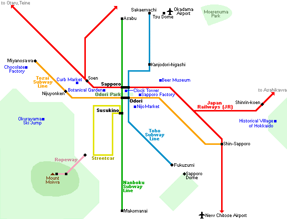
Sapporo has three subway lines and one tram line but Ōdōri is only 4-5 blocks (or one subway stop) away from Sapporo station and Susukino, Sapporo's main entertainment and restaurant district, is 4 further blocks (or one subway stop) away.
 Japan-Guide.com
Map of central Sapporo (PDF)
Sapporo Info app
Sapporo weather forecast
https://www.accuweather.com/en/jp/sa...weather/223985
Japan-Guide.com
Map of central Sapporo (PDF)
Sapporo Info app
Sapporo weather forecast
https://www.accuweather.com/en/jp/sa...weather/223985