


 Mar 7, 2014, 7:56 pm
Last edit by: JDiver
PLEASE READ FIRST: WELCOME and MODERATOR NOTE
If you are new to us, welcome to FlyerTalk!
If you are new to us, welcome to FlyerTalk!
Who we are: FlyerTalk features discussions and chat boards that covers the most up-to-date traveler information; an interactive community dedicated to the topic of travel.
All travelers are welcome in the community. Just choose a forum: conversing about airlines and their programs, airports, destinations, dining and how to make the most of your miles and points, or visit our Information Desk to start.
All travelers are welcome in the community. Just choose a forum: conversing about airlines and their programs, airports, destinations, dining and how to make the most of your miles and points, or visit our Information Desk to start.
Respect our Diversity - link to this guideline
FlyerTalk members come from all walks of life and all parts of the world. We are as diverse in our makeup as we are alike in our passion for frequent flyer programs. Because we all bring a unique perspective to the forum, our collective experience is broadened, and we gain new insights.
Our diversity demands that we respect each other. Due to the inherent constraints of the Internet, humor, sarcasm, language and slang can be easily misinterpreted - especially when crossing cultural boundaries.
When posting a message, pay extra care to how it might be interpreted. And when you come across a post that offends you, read it with an eye toward giving the poster the benefit of the doubt.
If you have an issue with a post, please contact the member privately or contact a moderator (click on the button). Do not make a situation worse by publicly responding.
FlyerTalk members come from all walks of life and all parts of the world. We are as diverse in our makeup as we are alike in our passion for frequent flyer programs. Because we all bring a unique perspective to the forum, our collective experience is broadened, and we gain new insights.
Our diversity demands that we respect each other. Due to the inherent constraints of the Internet, humor, sarcasm, language and slang can be easily misinterpreted - especially when crossing cultural boundaries.
When posting a message, pay extra care to how it might be interpreted. And when you come across a post that offends you, read it with an eye toward giving the poster the benefit of the doubt.
If you have an issue with a post, please contact the member privately or contact a moderator (click on the
button). Do not make a situation worse by publicly responding.
Please note: Insensitive or attacking posts, discussion about other posters and their motives, OMNI conspiracy theories, ad hominem, etc. will be summarily deleted. Please follow the TOS when discussing this tragedy: essentially, "These matters are always personal and should be treated with respect." Family members and other affected parties may be following this thread. Gross speculation and the rumors that are apt to be spread initially are not helpful to them or to us.
Moderation of this thread will be strictly "to rules". Moreover, because of how quickly this thread is moving, it is simply not possible to contact each individual poster whose post may be deleted or edited. We ask for your patience and understanding, and thank you for your cooperation.
--> If you have a question or comment about moderation, use the "Alert a Moderator" button left of every post, or send a PM. Do not post such comments/questions on-thread.
Your Moderator team for this thread: aBroadAbroad; cblaisd; JDiver; l'etoile; NewbieRunner; oliver2002; Prospero
MH370 Discussion and Speculation Thread is now open to keep this thread focused on confirmed news and known facts, and to allow folks to discuss their ideas about what might have happened
Archived older posts:
MH 370 KUL-PEK Missing: 8 - 15 Mar 2014 UTC - ARCHIVE WEEK #1
MH 370 KUL-PEK Missing: 15 - 21 Mar 2014 UTC - ARCHIVE WEEK #2
FREQUENTLY ASKED QUESTIONS / FAQ has been inserted into Post #1 of this thread.
Malaysia Airlines has provided the following contact numbers for passengers' families: +603 7884 1234 (Kuala Lumpur) or +8610 6437 6249 (Beijing)
This thread now begins with posts made after 0536 UTC 22 March 2014..
N.B. Please do not alter the above message.
Moderation of this thread will be strictly "to rules". Moreover, because of how quickly this thread is moving, it is simply not possible to contact each individual poster whose post may be deleted or edited. We ask for your patience and understanding, and thank you for your cooperation.
--> If you have a question or comment about moderation, use the "Alert a Moderator" button
left of every post, or send a PM. Do not post such comments/questions on-thread.Your Moderator team for this thread: aBroadAbroad; cblaisd; JDiver; l'etoile; NewbieRunner; oliver2002; Prospero
MH370 Discussion and Speculation Thread is now open to keep this thread focused on confirmed news and known facts, and to allow folks to discuss their ideas about what might have happened
Archived older posts:
MH 370 KUL-PEK Missing: 8 - 15 Mar 2014 UTC - ARCHIVE WEEK #1
MH 370 KUL-PEK Missing: 15 - 21 Mar 2014 UTC - ARCHIVE WEEK #2
FREQUENTLY ASKED QUESTIONS / FAQ has been inserted into Post #1 of this thread.
Malaysia Airlines has provided the following contact numbers for passengers' families: +603 7884 1234 (Kuala Lumpur) or +8610 6437 6249 (Beijing)
This thread now begins with posts made after 0536 UTC 22 March 2014..
N.B. Please do not alter the above message.
• • • • •
WIKIPOST
This wiki may be minimized or maximized by clicking on [-] or [+] box at upper right corner of post.
Signed-in members with 90 days / 90 posts on FlyerTalk may edit this Wikipost with updates.
Please report all times in UTC - Coordinated Universal Time (GMT - Greenwich Mean Time, Z - Zulu time) in order to
avoid confusion caused by complex time zone boundaries in the incident area.
SUMMARY: MH370 departed Kuala Lumpur for Beijing with 227 passengers and 12 crew early morning March 8 2014. After what appeared to be a normal departure, a handoff to Vietnamese ATC was not finalized - communications and secondary radar data no longer were transmitted. The aircraft has been assumed to fly on for 7 hours on an initially circuitous route and to have been lost at sea in the southern Indian Ocean, 1,500 mi / 2,500 km sw of Perth.
No operating theory has been put forth that provides a probable explanation of who has flown the aircraft nor for what possible purpose as of 27 March. Link to BBC written and video summary of the flight of MH370.
No operating theory has been put forth that provides a probable explanation of who has flown the aircraft nor for what possible purpose as of 27 March. Link to BBC written and video summary of the flight of MH370.
LATEST NEWS
In reverse chronological order:
*All times regarding activities within the search area are expressed in Australian Western Standard Time (AWST). Please note all times are approximate.
Sunday, 8 March 2015
On the first anniversary of the disappearance of MH370 an interim report was released by Malaysia's Ministry of Transport.
http://mh370.mot.gov.my/
Friday, 11 April 2014 - pm AWST (JACC)
The Chief Coordinator of the Joint Agency Coordination Centre, Air Chief Marshal Angus Houston (Ret'd), said an initial assessment of the possible signal detected by a RAAF AP-3C Orion aircraft yesterday afternoon has been determined as not related to an aircraft underwater locator beacon.
Friday, 11 April 2014 (BBC and other sources)
Australian leader Tony Abbott says authorities are confident that signals heard in the Indian Ocean are coming from the "black box" flight recorders of the missing Malaysia Airlines plane. Link
Thursday, 10 April 2014 - pm AWST (JACC)
The Chief Coordinator of the Joint Agency Coordination Centre, Air Chief Marshal Angus Houston (Ret'd), has confirmed that whilst conducting an acoustic search this afternoon a RAAF AP-3C Orion aircraft has detected a possible signal in the vicinity of the Australian Defence Vessel Ocean Shield.
"The acoustic data will require further analysis overnight but shows potential of being from a man-made source," Air Chief Marshal Houston (Ret'd) said.
"I will provide a further update if, and when, further information becomes available."

Wednesday, 9 April 2014 (BBC)
An Australian vessel heard the signals again on Tuesday afternoon and evening.
Signals heard earlier had also been further analysed by experts who concluded they were from "specific electronic equipment".
Experts at the Australian Joint Acoustic Analysis Centre had also analysed the first two signals heard over the weekend.
Their analysis showed that a "stable, distinct and clear signal" was detected. Experts had therefore assessed that it was not of natural origin and was likely from specific electronic equipment.
Wednesday, 9 April 2014—am AWST (JACC)
Up to 11 military aircraft, four civil aircraft and 14 ships will assist in today's search for missing Malaysia Airlines flight MH370.
Today AMSA has planned a search area of about 75,423 square kilometres.
The centre of the search area is approximately 2261 kilometres north west of Perth.
A weak front is moving in from the south east, expected to bring scattered showers.
The underwater search continues today, with ADV Ocean Shield at the northern end of the defined search area, and Chinese ship Haixun 01 and HMS Echo at the southern end.
Tuesday, 8 April 2014—am AWST (JACC)
Up to eleven military planes, three civil planes and 14 ships will assist in today's search for missing Malaysia Airlines flight MH370.
AMSA has directed the search of one large search area today of approximately 77,580 square kilometres, 2268 kilometres north west of Perth.
Good weather is expected for searching throughout the day.
The underwater search continues, with ADV Ocean Shield at the northern end of the defined search area, and Chinese ship Haixun 01 and HMS Echo at the southern end.
Monday, 7 April 2014
An Australian military vessel has detected signals consistent with those emitted by an aircraft black box, indicating a potential breakthrough in the search for missing Malaysia Airlines flight MH370.
Two separate signals have been detected by Australian Defence Vessel Ocean Shield in the northern part of the search area.
In what he called "a most promising lead", Air Chief Marshal (ret) Angus Houston revealed that "the pinger locator has detected signals consistent with those emitted by aircraft black boxes". (Sydney Morning Herald, and others)
Monday, 7 April 2014—am AWST (JACC)
Up to nine military planes, three civil planes and 14 ships will assist in today's search for missing Malaysia Airlines flight MH370.
The search area is expected to be approximately 234,000 square kilometres.
Good weather is expected throughout the day with showers in the afternoon although this is not expected to affect the search.
ADV Ocean Shield is continuing investigations in its own area.
HMS Echo is en route to assist the Chinese vessel Haixun 01, which detected pulse signals in the Indian Ocean.
The Australian Transport Safety Bureau continues to refine the area where the aircraft entered the water based on continuing ground-breaking and multi-disciplinary technical analysis of satellite communication and aircraft performance, passed from the international air crash investigative team comprising analysts from Malaysia, the United States, the UK, China and Australia.
Retired Air Chief Marshal Angus Houston (JACC dirrector): "This is an important and encouraging lead". BBC Video.
Up to 10 military planes, 2 civil planes and 13 ships will assist in Sunday's search for missing Malaysia Airlines flight MH370.
The Australian Maritime Safety Authority (AMSA) has three separate search areas planned for today about 2,000 kilometres north west of Perth, which total approximately 216,000 square kilometres.
Weather in the search area is expected to be good with a cloud base of 2,500 feet and visibility greater than 10 kilometres.
Reports overnight that the Chinese ship, Haixun 01, has detected electronic pulse signals in the Indian Ocean related to MH370 cannot be verified at this point in time.
Saturday 5 April 2014:
The Chinese maritime patrol ship Haixun 01 has picked up a 37.5 kHz pulse signal, according to Chinese media. Though there is no evidence it is from the MH370 "black box", the frequency is the same as used by fight recorders. (Xinhuanet, others)
5 April 2014—am - (JACC)
~10 military planes, three civil jets and 11 ships participated in today's search. ADV Ocean Shield and HMS Echo continued underwater search operations searching with TPL-25 towed pinger locator.
Weather was fair, with possible showers.
Friday 4 April 2014—JACC
Up to 10 military planes, four civil jets and nine ships participated in today's search for missing Malaysia Airlines flight MH370. One civil aircraft operated to provide communications relay.
The weather was is fair, with visibility approximately 10 kilometres and a cloud base between 1000 and 2000 feet.
Two ships, the HMAS Ocean Shield and HMS Echo, towed TPL-25 "towed pinger locators" to search for the "black box" 37.5 kHz signal; the "black box" (Flight Data and Cockpit Voice Recorder assembly) is powered for approximately 30 days.
Thursday 3 April 2014—am JACC
Up to eight planes (one dropping marker buoys) and nine ships were deployed on the SAR mission, an area of about 223,000 square kilometres, 1680 kilometres west north-west of Perth. Weather fair, with visibility approximately 10 kilometres, however the southern area may experience some isolated showers. No new findings today.
Wednesday, 2 April 2014 - JACC
Up to ten planes (one providing relay services) and nine ships will assist in today's search for missing Malaysia Airlines flight MH370. AMSA search area about 221,000 square kilometres,1504 kilometres North West of Perth.
British nuclear-powered Trafalgar class submarine HMS Tireless , with 138 crew including 18 officers, has joined the hunt for missing Malaysia Airlines flight MH370; the UK MOD has said it would assist in searchng for the "black box". (BBC)
Monday, 31 March: (AMSA Update #31, 8.00am (AEDT) 0000 UTC
10 aircraft searching, no notable results. The ADV Ocean Shield was scheduled to depart from Perth today. It has now been fitted with a black box detector and an autonomous underwater vehicle. Some parts of the search area will experience low cloud and rain throughout the day.
Sunday, March 30, 2014 AEDT: The search activities continued in an area about 1,850 kilometres west of Perth, focused on an area of about 319,000 square kilometres. Eight aircraft were involved in today’s search.
Ten ships arrived or were on station today: HMAS Success, the Chinese Maritime Safety Administration ship Haixun 01, China Rescue and Salvage Bureau ship Nan Hai Jiu, and the Chinese Navy vessel Jinggang Shan.All ships in the search area were tasked to locate and identify the objects sighted by aircraft over the past two days.
Weather in the search area included light showers and low cloud, though search operations are expected to continue.
AMSA Update #28, 30 March 2014: 0645(AEDT)
Debris spotted and identified by ship turned out to be fishing debris - a fishing vessel is missing and the search for the vessel has now been discontinued after finding the debris. - AMSA
Saturday, March 29, HMAS Success, the Chinese Maritime Administration patrol ship, Haixun 01, PLAN vessel Jinggangshan (carrying two helicopters) were active Saturday; the later specifically is searching for debris, oil slicks, lifejackets, etc. Eight aircraft were also launched today. A IL-76 from China spotted some small colourful debris (orange, white and red), dropped a marker and left the debris to be checked by ship - the debris, recovered and checked by Haixun 01, was not related to MH370. Weather began nicely but has been deteriorating today; the search day is over now. (National News Agency of Malaysia, BBC and others.)
The ANZAC class frigate HMAS Toowoomba left Perth this evening and is due to arrive in the search area in about three days.
Friday March 28 local time end of search day: Ten aircraft searched an area of nearly 100,000 sq mi / 256,000 sq km today. Five aircraft spotted debris in the new search area; another aircraft spotted debris 546 km away.
● AMSA announcement PDF
The search area has shifted northeastward ~1,100 km / 700 mi based on the theory the aircraft was flying faster than previously believed (skewing the imputed flight path and decreasing range based on available fuel). The new search area is approximately 123,127 sq mi / 319,000 sq km and around 1,150 mi / 1,850 km west of Perth. Satellites are being redeployed to survey the new search area. (Aviation Herald, Malay Mail online and others; BBC article link)
The Malaysian government is expected to appoint an international panel on aviation security along with a parliament select committee to probe overall airline safety... an official said in Kuala Lumpur on Saturday (29 Mar 2014).
Tuesday, 26 Mar, search activities were halted by Sea State 7; resumed Wednesday, Thursday 28 Mar again saw aircraft withdrawn from search activities.
If potential debris is spotted by satellite, further identification must be done by aircraft, and then recovered by ships for analysis. If debris proves positive from MH370, further analysis must determine drift distance and angle to a possible crash site. This all depends on the weather holding as well, though at least the search is no longer focused in the "Roaring Forties".
Soon, a US Navy Towed Pinger Locator will be towed by the HMAS Ocean Shield to try to detect "pings" from the aircraft's "black box", which is actually orange and consists of the Cockpit Voice Recorder (two hour loop) and Flight Data Recorder (25 hours continuous).
● BBC page on "black box" link
● BBC video "black box" search link.
If air and sea search fails, or further narrowing of the search area is required, sonar will be deployed and used. Support and research vessels, some of them with sonar and one with the U. S. autonomous underwater Bluefin 21, will then try to find the wreck amongst the sea bottom topography.
● BBC sonar search video link.
Information reveals that Malaysia Airlines chose not to add an upgrade to aircraft communications ("Swift") that could have continually transmitted aircraft data even with ACARS shut down. Rather than pay the cost of USD $10.90 per flight, MH opted to download the data to a USB thumb drive after the end of a flight, according to various sources. http://www.washingtonpost.com/world/...f19_story.html
Monday, 24 March, Malaysian prime minister announced that new satellite data showed that flight MH370 crashed into the Indian Ocean. In a brief statement he said: "It is with deep sadness and regret that I must inform you that... flight MH370 ended in the southern Indian Ocean." The ongoing multinational search operation would continue as they seek answers to the questions which remain.
Partners Inmarsat and SITA AIRCOM, UK and US aviation safety and security officials have determined MH370 may have flown up to seven hours beyond the point of last radar location; MH370 apparently broadcast automated hourly engine maintenance code "pings" received by satellite operator Inmarsat.
New satellite analysis techniques developed by British firm Inmarsat and the UK's Air Accidents Investigation Branch (AAIB) have "concluded that MH370 flew along the southern corridor, and that its last position was in the middle of the Indian Ocean", said Malaysian PM Najib Razak.
"This is a remote location, far from any possible landing sites. It is therefore with deep sadness and regret that I must inform you that, according to this new data, flight MH370 ended in the southern Indian Ocean."
Debris is being searched for, but the USA is sending a Towed Pinger Locator towed sled equipped to find "pingers" such as the "black box" pinger, which is designed to be powered for 25 - 30 days.
A number of aircraft, including four long range commercial planes, three RAAF and one RNZAF P-3 Orion anti-submarine surveillance aircraft, one USN P8 Poseidon, two Chinese IL-76 and two JASDF P-3 Orion aircraft are searching, joined by a Korean (ROKAF) P-3 Orion and C-130H. The ASW aircraft have observation ports for observers, Magnetic Anomaly Detector gear and can deploy various sonobuoys, etc.
Chinese, British and Australian naval ships have joined Australian supply ship HMAS Success, including China's ice-breaking Xuě Lóng (Snow Dragon) research vessel, (involved in the recent Antarctic rescue of the MV Akademik Shokalskiy) and three Chinese PLAN warships QianDaoHu, KunLunShan and Haikou, as well as merchant ship Zhonghai Shaohua, are participants as well. The U.K. is sending HMS Echo to join the search (has departed the Maldives), China is sending more vessels.
The HMAS Ocean Shield will be fitted on 28 Mar with the US "TPL" (Towed Pinger Locator) and "...is expected to reach the search area by 5 April, giving it only two days before the pinger's batteries possibly start to fade at 30 days."
The US is sending a UUV (autonomous unmanned underwater vehicle) Bluefin-21, designed by Bluefin Robotics, equipped with side-scanning sonar and a "multi-beam echo sounder" which can examine underwater objects in detail and operate in depths of up to 4,500 metres (14,700 ft) (BBC).
Malaysia has asked the FBI to help recover data it said was deleted from a home flight simulator belonging to the plane's chief pilot, Captain Zaharie Ahmad Shah, but otherwise no evidence has emerged to implicate him or the crew. FBI announced on 26 Mar a couple of more days are needed, but so far they have found no forensic evidence against Capt. Zaharie.
Please continue to use indigo text to highlight your changes until the next maintenance period (after ~00:01 UTC Friday).
Summary of events in the FAQ (Post #1) and what we think we know as of 14 Mar, 1727 UTC in this post.
EXTERNAL SOURCES
Aviation Herald — possibly the best and most objective summary in general, latest updates are highlighted in yellow — last updated on Sunday, Apr 6, 2014 at 11:40 UTC.
MH370 Flight Incident - official announcements by Malaysia Airlines
BBC tabbed pages with newest news of the MH370 incident
BBC: Ten Theories of MH370's Disappearance
Malaysian Prime Minister's statement that MH370 ended in the southern Indian Ocean, March 24, 2014 Youtube video
Live updates (Yahoo News Singapore)
Streaming news (WSJ)
Reuters graphics: story, search and emergency
How a pilot deals with an emergency. (BBC, Capt. Philip Riddell <spelling in conflict with BBC>)
Summary of events, known information and technical background Airliners.net
THREAD SUMMARY
Please Edit and Update as Needed! Please Use Indigo Text to Highlight Changes!
Please Edit and Update as Needed! Please Use Indigo Text to Highlight Changes!
NOTE: While links to relevant and reasonably reliable news sources are welcome, please take a few minutes to scroll back a couple dozen posts to make sure a similar story hasn't already been posted. There have been many well-meaning posters eager to share “breaking news” that ends up having been posted by others hours before. Thanks for helping us to avoid redundancy and repetition!
Time Frame Confusion
Sources may appear to be reporting conflicting timeframes for various stages of the incident. However, this is likely due to confusion about time zone changes between Malaysia (last ATC contact) and Vietnam (next ATC contact) - see time zone map here for boundaries. Please report times in UTC/GMT wherever possible.
SAR / Search and
NOTE: Discussion of opinions and perspectives on SAR costs and timeliness, which involves coordination of 26 nations' civil and military authorities, is beyond the scope of this thread. Users have been advised to shift such discussion to OMNI - see post #2047. Thanks for your cooperation.
Reports indicate latest satellite ping around 0811 MYT (0011 GMT/UTC/Zulu), or nearly 7 hours after contact was lost.
Boeing and Rolls Royce have teams on site; the NTSB (USA) and UK AAIB are involved due to US and UK manufacture of aircraft and engines, France's BEA due to AF447 similarities and other resources are likely to be invited to assist. The U. S. FBI has become involved in investigating the crew, passengers and ground staff.
Reports that the aircraft climbed to 45,000 feet, above its service ceiling, and as low as 5,000 ft remain unverified. More here and in posts #3894 on.
Malaysia Airlines has issued a statement that the shipment of lithium-ion batteries was in compliance with the International Civil Aviation Organisation (ICAO) and the International Air Transport Association (IATA) requirements, where it is classified as "non-dangerous goods".
Disproven Reports to Date
Early reports that the plane had landed in Nanming, Vietnam or Nanning, China, have been disclaimed by Chinese authorities and MH leadership.
All reports of possible aircraft debris, up to and including a possible debris field off the southeast coast of Vietnam, China SASTIND satellite imagery from 9 Mar debris reported 105.63 east longitude, 6.7 north latitude investigated 12 Mar have been discredited. The latter is now "a mistake", according to SASTIND. Read more here.
Possible fuel slicks identified early on have been tested and determined NOT to be aircraft fuel.
Various life rafts found in the SAR ops area have been unrelated to the missing aircraft. See one example at this post.
Reports of another pilot contacting MH370 have been discredited.
Reports of passenger cell phones still ringing when called are almost certainly an artifact of international telephony - see explanation by one FTer at post #1832.
All claimed ground observations of the aircraft (Malaysia, Vietnam oil platform, etc.) data are unverified at this time.
Beware of data from sites like FlightRadar24, FlightAware, etc. These data are not entirely reliable, as they are synthesized; erroneous readings may be present on some sites. The aircraft could not climb to 49,500 feet as some sites may indicate, as this is considerably above the aircraft's design ceiling.
Authorities deny that five other passengers checked in for the flight, but did not board, stating the pax were actually no-shows who never checked in, and that no baggage was loaded for these five pax. Four standby passengers were accommodated.
Reports of seismic readings being possibly related to the aircraft crashing into seafloor have been described by experts as improbable. USGS records a natural earthquake off the west coast of Sumatra - info here
Other speculation (EMP, shot down, etc.) has been mentioned in the thread but currently has no basis, and is not appropriate for this thread. Please observe the moderator note at the beginning of this wiki.
Timeline/Facts (Please see FAQ / Post #1)
NOTE: flight number MH370/371 will be renumbered MH318/319 effective 14 March 2014
!!! REMINDER !!!
This thread is about the loss of MH370. In depth discussion of unrelated topics — geopolitics, passport theft, aviation security, airport security procedures, etc. — belongs in other fora. A few include:
OMNI/PR: Discussion of perspectives on politics and religion, including geopolitics and terrorism (requires 180 days on FT and 180 constructive posts prior to admission)
Travel Safety/Security: Checkpoints and Borders Policy Debate
Travel Safety/Security: Practical Travel Safety Issues for those discussing travel safety and security issues because they are planning a trip soon.
TravelBuzz: TravelBuzz for those wishing to discuss the relative safety of a specific aircraft - e.g. Boeing 777.
We have a number of Destination fora to discuss various aspects of destination travel (including airports, airport connections, etc.)
MAPS, IMAGERY, GRAPHICS
Please try to re-size your pictures to fit the normal width. We have had several folks (particularly, but not exclusively, those on mobile devices) request that the size of graphics be "normal."

Area of debris sightings and search
The original map was posted on BBC website but is too large to post here.
Ministry of Transport Malaysia:
INFORMATION PROVIDED TO MH370 INVESTIGATION BY UK AIR ACCIDENTS INVESTIGATION BRANCH (AAIB)
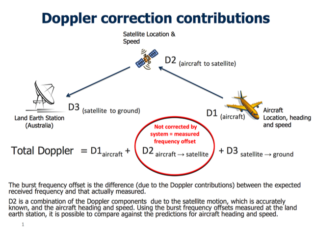
This diagram shows the Doppler contributions to the burst frequency offset.
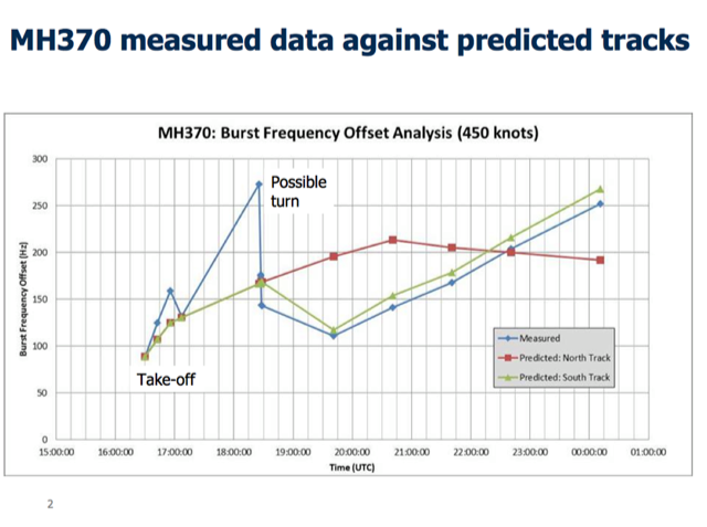
Blue line: the burst frequency offset measured at the ground station for MH370.
Green line: is the predicted burst frequency offset for the southern route, which over the last 6 handshakes show close correlation with the measured values for MH370.
Red line: predicted burst frequency offset for northern route (which over last 6 ACARS - Inmarsat "handshakes" does not correlate with the measured values for MH370).
INFORMATION PROVIDED TO MH370 INVESTIGATION BY UK AIR ACCIDENTS INVESTIGATION BRANCH (AAIB)
This diagram shows the Doppler contributions to the burst frequency offset.
Blue line: the burst frequency offset measured at the ground station for MH370.
Green line: is the predicted burst frequency offset for the southern route, which over the last 6 handshakes show close correlation with the measured values for MH370.
Red line: predicted burst frequency offset for northern route (which over last 6 ACARS - Inmarsat "handshakes" does not correlate with the measured values for MH370).
Archived maps
Map with calculated tracks (contribution by Reason077)
Nrg800 map showing runways within range, line of possible ping transmission and range limit from last radio contact.
See posts #4145 and #4163 for more info.
ADV Ocean Shield towed pinger locator detections - JACC
Signals detected by Chinese (5 April) and Australians (6 April) - BBC
Locations where signals were detected
Search area and location where possible signal detected, 6 April 2014 (BBC)
Search area and location where possible signal detected, 5 April 2014 (BBC)
Search area, 4 April 2014 (BBC)
Searach area, 2 April 2014 (BBC)
Search area, 1 April 2014 (BBC)
Search area, 30 March 2014 (BBC)
New search area, 28 March 2014 (BBC)
Detailed map of area of debris sightings and in original Indo-Australian search area (BBC)
Area of debris sightings
How big is the search area?
BBC map of search zones
BBC area and key events map
BBC possible final aircraft track map
NOTE: SEE FAQ (POST #1 - click to pop up in separate window) FOR FREQUENTLY ASKED QUESTIONS AND REPLIES, OTHER LINKS TO RESOURCES AND PREVIOUS GRAPHICS FROM THIS WIKI.

MH370 KUL-PEK Missing 8 Mar 2014: Search & Recovery [PLEASE SEE WIKI]
May 8, 2014, 7:38 am
#301
FlyerTalk Evangelist
Join Date: Oct 2009
Location: ATL Lost Luggage
Programs: Kettle with Kryptonium Medallion Tags
Posts: 10,265
May 5, 2014 JACC Release: Ocean Shield resupplies and continues the Search
May 5 JACC Media Release: Ocean Shield resupplies and continues the Search
Ocean Shield resupplies and continues the Search
Media Release
5 May 2014—pm
Ocean Shield will today return to Fleet Base West to replenish its supplies and conduct routine maintenance and software modifications to Phoenix Autonomous Underwater Vehicle ‘Artemis’ Bluefin-21.
On completion of the short port visit, Ocean Shield will return immediately to the search area where the underwater search for missing Malaysia Airlines flight MH370 will continue.
The just-completed deployment began on 31 March with 56 personnel and specialist search equipment including a Towed Pinger Locator and Phoenix Autonomous Underwater Vehicle ‘Artemis’ Bluefin-21.
Although the search to date has not uncovered any evidence of possible aircraft debris during operations, the data collected during the 35 days at sea will assist in narrowing the search area for the final resting place of MH370.
The Australian Government is proud of the combined efforts of the Royal Australian Navy, United States Navy, civilian contractors from Phoenix International, Australian Transport Safety Bureau and the ship's crew.
Also at the request of the Australian Government, the U.S. Navy will continue supporting the MH370 sub-surface search effort with the Bluefin-21 side scan sonar for approximately 4 more weeks.
 May 13, 2014, 5:10 am
#302
Join Date: Jan 2012
Location: Victoria, Australia
Programs: Qatar, Qantas club, Enrich, Skywards
Posts: 45
Cost of search for MH370 to Australia
Australian budget just handed down and search for MH370 is stated to possibly last "years" and cost up to Au$89.9 million
http://www.news.com.au/finance/econo...-1226916454414
http://www.news.com.au/finance/econo...-1226916454414
Last edited by aussienanna; May 13, 2014 at 5:12 am Reason: Corrected dollar cost
 May 15, 2014, 9:07 am
#303
FlyerTalk Evangelist
Join Date: Oct 2009
Location: ATL Lost Luggage
Programs: Kettle with Kryptonium Medallion Tags
Posts: 10,265
May 15, 2014 JACC Release: Update on MH370 Search [Bluefin-21 Damaged]
May 15 JACC Media Release: Update on MH370 Search
Update on MH370 Search
As advised yesterday, the Autonomous Underwater Vehicle, Bluefin-21, was recovered about two hours into its first mission since returning to the search area so a communications problem could be investigated.
During the recovery, Bluefin-21 was damaged but was able to be repaired expeditiously with spare parts on board the ADV Ocean Shield.
Examination of the communications problem has established that a hardware defect exists in the transponder mounted on the Ocean Shield and that a defect may also exist in the transponder mounted on the Bluefin-21. This inhibits the ability of the two devices to communicate with each other.
As a consequence, spare parts for both defects will be dispatched from the United Kingdom. The parts are expected to arrive in Western Australia on Sunday.
Ocean Shield is currently en route to Dampier, Western Australia, to receive the transponder parts. The journey is anticipated to take a number of days. At this stage, Ocean Shield is expected go alongside so engineers can make a full assessment of the transponder repairs.
The Joint Agency Coordination Centre will provide further information regarding the serviceability of Bluefin-21 and the movements of Ocean Shield as it becomes available.
May 19, 2014, 9:26 am
#304
FlyerTalk Evangelist
Join Date: Oct 2009
Location: ATL Lost Luggage
Programs: Kettle with Kryptonium Medallion Tags
Posts: 10,265
May 19, 2014 JACC Release [Chinese Ship Zhu Kezhen to conduct bathymetric survey]
May 19 JACC Media Release: Update on MH370 Search
Update on MH370 Search
DV Ocean Shield arrived at Geraldton, Western Australia, yesterday to begin preparations to receive spare parts related to the transponder mounted on the Ocean Shield and the transponder mounted on the Autonomous Underwater Vehicle, Bluefin-21.
The repairs are necessary to correct a hardware issue affecting the ability of the transponders to communicate with each other during a dive. The problem became apparent during Bluefin-21's last mission on Tuesday.
Ocean Shield was originally going to Dampier to await the transponder parts, however, it was determined that the parts could be delivered to the ship more quickly via the port of Geraldton.
The spare parts are expected to arrive in Geraldton later today.
Once the replacement parts are installed, testing will be conducted at Geraldton prior to Ocean Shield transiting back to the search area.
Malaysian, Australian and Chinese authorities met over the weekend in Fremantle to discuss the bathymetric survey.
It was agreed that the Chinese survey ship Zhu Kezhen will conduct the bathymetric survey of the areas provided by the Australian Transport Safety Bureau.
Zhu Kezhen is scheduled to sail for the survey area on Wednesday, weather permitting.
May 21, 2014, 11:26 pm
#305
Join Date: Jan 2012
Location: Victoria, Australia
Programs: Qatar, Qantas club, Enrich, Skywards
Posts: 45
Update for 22nd May 2014
Latest update from JACC:
http://jacc.gov.au/media/releases/2014/may/mr047.aspx
http://jacc.gov.au/media/releases/2014/may/mr047.aspx
22 May 2014—pm
ADV Ocean Shield has arrived back in the search area.
The Autonomous Underwater Vehicle, Bluefin-21, was deployed from the vessel around 2am this morning. It remains underwater on its search mission.
Over the next week, Bluefin-21 will search the remaining areas in the vicinity of the acoustic signals detected in early April by the Towed Pinger Locator deployed from Ocean Shield that are within its depth operating limits.
This continues the process that will ultimately enable the search team to discount or confirm the area of the acoustic signals as the final resting place of MH370.
Ocean Shield is anticipated to depart the search area on 28 May and return to Fleet Base West on 31 May where it will demobilise the Autonomous Underwater Vehicle equipment and disembark the support team.
The Chinese survey ship Zhu Kezhen departed Fremantle yesterday to begin conducting the bathymetric survey of the areas provided by the Australian Transport Safety Bureau. The bathymetric survey—or mapping of the ocean floor—is being done in preparation for a commercially contracted deep ocean search, including towed side-scan sonar operations.
Chinese ship Haixun 01 will today begin transiting to the survey area to support the survey operations, including the weekly transportation of survey data to Fremantle for further processing by Geoscience Australia.
The Australian Defence Force's Military Coordination and Sub-Surface Planning team, in consultation with the Australian Transport Safety Bureau, will partner with Chinese units to conduct the survey.
The work continues to review and analyse all the data and information relating to the likely flight path of MH370, together with the information acquired in the course of the search to date. This work will confirm the best areas on which to focus an effective future search.
Last edited by NewbieRunner; May 22, 2014 at 12:19 am Reason: added text of news release
May 26, 2014, 10:58 am
#306
Join Date: Jan 2014
Location: SAN/LAX
Programs: UA Gold, VX Silver, HH Gold, Hyatt Gold, JPM Palladium
Posts: 627
Raw Data From Inmarsat May Be Released on Tuesday
Analysis of satellite data had led experts to believe that MH370 had gone down in the Indian Ocean off the coast of Australia, but after many weeks of searching nothing has been found. Now a Malaysian official has reportedly stated that raw satellite about the missing jet will be released tomorrow/Tuesday in an effort in increase search effort transparency. Once released, independent analysis of the data will be possible.
http://www.cnn.com/2014/05/26/world/...missing-plane/
http://www.thestar.com.my/News/Natio...attelite-data/
http://www.themalaymailonline.com/ma...-minister-says
UPDATE: The data has been released.
http://bigstory.ap.org/article/malay...ta-missing-jet
http://www.reuters.com/article/2014/...A4Q01920140527
Last edited by FTcadence; May 26, 2014 at 11:15 pm
May 28, 2014, 6:24 pm
#307
Join Date: Jan 2012
Location: Victoria, Australia
Programs: Qatar, Qantas club, Enrich, Skywards
Posts: 45
Australian Safety Transport Bureau update site
The link below gives insight in to the latest plans in the search for MH370. It also contains links to fact sheets which are informative.
http://www.atsb.gov.au/mh370.aspx
In the meantime, CNN is reporting that the pings were not from the black boxes but some other man made source.
http://edition.cnn.com/2014/05/28/wo...lines-pinging/
ABC have the following notice onscreen
http://www.abc.net.au/news/2014-05-2...-plane/5487052
"The search for MH370 continues
Monday May 26, 2014
By Martin Dolan, Chief Commissioner
It’s now been more than 11 weeks since Malaysia Airlines flight MH370 disappeared from air traffic control radar after taking off from Kuala Lumpur on a scheduled passenger service to Beijing.
Despite one of the most intensive and coordinated air and sea search efforts ever undertaken, there has not yet been any sign of the missing aircraft.
The complexities surrounding the search cannot be understated. It involves vast areas of the Indian Ocean with only limited known data and aircraft flight information. While it is impossible to determine with certainty where the aircraft may have entered the water, all the available data indicates a highly probable search area close to a long but narrow arc of the southern Indian Ocean.
It is now highly unlikely that surface debris from the aircraft will be spotted. This means that the most effective way to continue the search is to look for MH370 under the water.
The search will be a major undertaking.
The complexities and challenges involved are immense, but not impossible.
Following an announcement by the Prime Minister of Australia in late April, and at the request of the Malaysian government, the ATSB is planning an intensified underwater search of a 60,000 square kilometre area—roughly the size of Tasmania.
As part of its search operations, the ATSB’s initial work involves:
reviewing existing information, from an expert satellite working group, to refine a search zone of up to 60,000 square kilometres in the southern Indian Ocean
conducting a bathymetric survey to map the search area
consulting with domestic and international authorities—including various oceanographic institutions and private companies—to prepare the plan and specialist services required for the next search phase.
The bathymetric survey— or mapping of the ocean floor— has already commenced, with the Chinese survey ship Zhu Kezhen conducting a survey of the areas provided by the ATSB. Zhu Kezhen will shortly be joined by a contracted commercial survey vessel in June. Taking around three months to complete, the bathymetric survey will give us crucial knowledge of the seafloor terrain needed to begin the underwater search.
The intensified underwater search will aim to locate the aircraft and any evidence (such as aircraft debris and flight recorders) to assist with the Malaysian investigation. The equipment used for the search will likely include a towed sonar, an Autonomous Underwater Vehicle with mounted sonar, and optical imaging equipment. We expect the search to begin in several months and take up to 12 months to complete.
The search will be a major undertaking. The complexities and challenges involved are immense, but not impossible. The best minds from around the world have been reviewing, refining and localising the most likely area where the aircraft entered the water, which is why we remain confident of finding the aircraft.
I encourage you to visit the ATSB’s MH370 webpage. The page features a series of factsheets that provide a great deal of detail on our underwater search operations. We will also provide regular updates on the page as significant information comes to hand."
In the meantime, CNN is reporting that the pings were not from the black boxes but some other man made source.
http://edition.cnn.com/2014/05/28/wo...lines-pinging/
ABC have the following notice onscreen
Breaking news
ATSB "discounts" Indian Ocean search area where pings heard as final resting place for MH370
ATSB "discounts" Indian Ocean search area where pings heard as final resting place for MH370
Last edited by NewbieRunner; May 28, 2014 at 11:52 pm Reason: OP Breaking news update and gave recognition to direct quote; NBR added quote codes
May 29, 2014, 2:18 am
#308
Join Date: Nov 2007
Location: SW London
Programs: BAEC Silver; Hilton Diamond;a miscellany of other hotel non-statuses
Posts: 3,607
BBC story with more info on search ruling out MH370 being in the 'ping area':
Read more at http://bbc.com/news/world-asia-27615173
The area where acoustic signals thought linked to the missing Malaysian plane were detected can now be ruled out as the final resting place of flight MH370, Australian officials say.
The Bluefin-21 submersible robot had finished its search of the area and found nothing, they said.
Efforts would now focus on reviewing search data, surveying the sea floor and bringing in specialist equipment.
The Bluefin-21 submersible robot had finished its search of the area and found nothing, they said.
Efforts would now focus on reviewing search data, surveying the sea floor and bringing in specialist equipment.
Last edited by aBroadAbroad; May 29, 2014 at 9:56 am Reason: Added excerpt of linked article per FT rules
May 29, 2014, 6:05 am
#309
FlyerTalk Evangelist
Join Date: Oct 2009
Location: ATL Lost Luggage
Programs: Kettle with Kryptonium Medallion Tags
Posts: 10,265
May 29, 2014 JACC Release: Update on MH370 Search
May 29 JACC Media Release: Update on MH370 Search
Update on MH370 Search
Media Release
29 May 2014—pm
Yesterday afternoon, Bluefin-21 completed its last mission searching the remaining areas in the vicinity of the acoustic signals detected in early April by the Towed Pinger Locator deployed from ADV Ocean Shield, within its depth operating limits.
The data collected on yesterday's mission has been analysed. As a result, the Joint Agency Coordination Centre can advise that no signs of aircraft debris have been found by the Autonomous Underwater Vehicle since it joined the search effort.
Since Bluefin-21 has been involved in the search, it has scoured over 850 square kilometres of the ocean floor looking for signs of the missing aircraft.
The Australian Transport Safety Bureau (ATSB) has advised that the search in the vicinity of the acoustic detections can now be considered complete and in its professional judgement, the area can now be discounted as the final resting place of MH370.
Ocean Shield departed the search area last night and is expected to arrive at Fleet Base West on Saturday.
As advised by the Australian Deputy Prime Minister on 5 May 2014, the search for MH370 continues and now involves three major stages:
The Chinese survey ship Zhu Kezhen has already begun conducting the bathymetric survey—or mapping of the ocean floor—of the areas provided by the ATSB. Its operations are being supported by the Chinese ship Haixun 01 and Malaysian vessel Bunga Mas 6 which are assisting with transporting the survey data to Fremantle weekly for further processing by Geoscience Australia. A contracted survey vessel will join the Zhu Kezhen in June.
The bathymetric survey is expected to take about three months. Knowing the seafloor terrain is crucial to enabling the subsequent underwater search.
The underwater search will aim to locate the aircraft and any evidence (such as aircraft debris and flight recorders) to assist with the Malaysian investigation of the disappearance of MH370.
It is anticipated that this component of the search will begin in August and take up to 12 months.
The ATSB will shortly release a formal request for tender to source the capability to undertake the underwater search. A single prime contractor will be chosen to bring together and manage the expertise, equipment and vessels to carry out the search.
The request for tender will be done via AusTender, the Australian Government Tender System: www.tenders.gov.au
Media Release
29 May 2014—pm
Yesterday afternoon, Bluefin-21 completed its last mission searching the remaining areas in the vicinity of the acoustic signals detected in early April by the Towed Pinger Locator deployed from ADV Ocean Shield, within its depth operating limits.
The data collected on yesterday's mission has been analysed. As a result, the Joint Agency Coordination Centre can advise that no signs of aircraft debris have been found by the Autonomous Underwater Vehicle since it joined the search effort.
Since Bluefin-21 has been involved in the search, it has scoured over 850 square kilometres of the ocean floor looking for signs of the missing aircraft.
The Australian Transport Safety Bureau (ATSB) has advised that the search in the vicinity of the acoustic detections can now be considered complete and in its professional judgement, the area can now be discounted as the final resting place of MH370.
Ocean Shield departed the search area last night and is expected to arrive at Fleet Base West on Saturday.
As advised by the Australian Deputy Prime Minister on 5 May 2014, the search for MH370 continues and now involves three major stages:
- reviewing all existing information and analysis to define a search zone of up to 60,000 square kilometres along the arc in the southern Indian Ocean;
- conducting a bathymetric survey to map the sea floor in the defined search area; and
- acquiring the specialist services required for a comprehensive search of the sea floor in that area.
The Chinese survey ship Zhu Kezhen has already begun conducting the bathymetric survey—or mapping of the ocean floor—of the areas provided by the ATSB. Its operations are being supported by the Chinese ship Haixun 01 and Malaysian vessel Bunga Mas 6 which are assisting with transporting the survey data to Fremantle weekly for further processing by Geoscience Australia. A contracted survey vessel will join the Zhu Kezhen in June.
The bathymetric survey is expected to take about three months. Knowing the seafloor terrain is crucial to enabling the subsequent underwater search.
The underwater search will aim to locate the aircraft and any evidence (such as aircraft debris and flight recorders) to assist with the Malaysian investigation of the disappearance of MH370.
It is anticipated that this component of the search will begin in August and take up to 12 months.
The ATSB will shortly release a formal request for tender to source the capability to undertake the underwater search. A single prime contractor will be chosen to bring together and manage the expertise, equipment and vessels to carry out the search.
The request for tender will be done via AusTender, the Australian Government Tender System: www.tenders.gov.au
May 31, 2014, 11:21 am
#310
FlyerTalk Evangelist
Join Date: Oct 2009
Location: ATL Lost Luggage
Programs: Kettle with Kryptonium Medallion Tags
Posts: 10,265
May 31, 2014 JACC Release: Update on MH370 Search (Zhu Kezhen suffered a defect)
May 31, 2014 JACC Media Release: Update on MH370 Search
Media Release
31 May 2014—am
The Chinese survey ship Zhu Kezhen which is conducting the bathymetric survey—or mapping of the ocean floor—is enroute to the port of Fremantle.
Zhu Kezhen suffered a defect to its multibeam echosounder and is coming into port to conduct the necessary repairs.
The journey is expected to take a couple of days. As previously advised, an Australian contracted survey vessel will also be involved in conducting the bathymetric survey and will arrive in the search area in June.
Further information regarding the movements of Zhu Kezhen will be advised if, and when, more information becomes available.
Jun 5, 2014, 2:16 pm
#311
Join Date: Jan 2012
Location: Victoria, Australia
Programs: Qatar, Qantas club, Enrich, Skywards
Posts: 45
The ATSB has added the following information to their website on 3rd June:
Quote:
http://www.atsb.gov.au/mh370/frequen...questions.aspx
On 4 June the ATSB also released a request for tender to acquire the services of a specialist company capable of conducting a deep-water search under ATSB direction for missing Malaysia Airlines Flight MH370. The relevant media release can be viewed on
http://www.atsb.gov.au/newsroom/2014...70-search.aspx
Link to the 7th Arc search area map
http://www.atsb.gov.au/mh370/search-area-map.aspx
Quote:
Frequently asked questions
How do you know MH370 is in the southern Indian Ocean?
All the evidence—based on independent analysis of satellite, radar and aircraft performance data from many international experts—indicates the aircraft entered the sea close to a long but narrow arc in the southern Indian Ocean. This arc has been the focus of the search efforts since late March. All future search operations will continue to take place in localised areas of the arc.
Why is the seventh satellite ‘handshake’ or arc so important?
The seventh handshake was the last communications MH370 had with the satellite. The signal was a logon request from the aircraft. This is consistent with the satellite communication equipment on the aircraft powering up following a power interruption. The interruption in electrical supply is highly likely to have been caused by fuel exhaustion. In other words, we are confident the seventh handshake represents the area where the aircraft ran out of fuel before entering the ocean.
Has the search been suspended?
No. The ATSB is leading the continuing underwater search for MH370.
The current phase of the search operation involves three major stages:
reviewing all existing information and analysis to define a search zone of up to 60,000 square kilometres along the arc in the southern Indian Ocean
conducting a bathymetric survey to map the sea floor in the defined search area (underway)
contracting the specialist services required for a comprehensive search of the sea floor in that area (search to begin in August 2014).
How long will the current underwater search take?
It is expected that the underwater search of a defined 60,000 square kilometre zone will take up to 12 months to complete, although this will depend on such factors as weather conditions.
Who is analysing the satellite communications data?
This work is being performed both independently and collaboratively by an international satellite communications group formed early in this search—this comprises staff from technical organisations and accident investigation agencies in the United Kingdom, the United States and Australia. This group is continuing to review and refine the satellite, radar and aircraft performance data to determine the most probable area where the aircraft entered the water.
On 4 June the ATSB also released a request for tender to acquire the services of a specialist company capable of conducting a deep-water search under ATSB direction for missing Malaysia Airlines Flight MH370. The relevant media release can be viewed on
http://www.atsb.gov.au/newsroom/2014...70-search.aspx
Link to the 7th Arc search area map
http://www.atsb.gov.au/mh370/search-area-map.aspx
Last edited by aussienanna; Jun 5, 2014 at 8:13 pm Reason: 7th Arc map link added
Jun 5, 2014, 10:58 pm
#312
Join Date: Jun 2014
Posts: 1
Recap - Bluefin-21 Search Grid
The following graphic was compiled from photographic evidence available from images.defence.gov.au and shows the 5 x 8km (40km2) search grids laid out on a transverse Mercator projection, along with the #1 ping, #1 LOS and #2 ping detections made on 05 April 2014.

I know that JACC have stated the search area was centred on the 2nd ping detection of 08 April, but the evidence is to the contrary, with Ocean Shield AIS position reports clearly backing up the above content. In fact the OS was working in C11 prior to diverting to Geraldton, WA, and on return was working in E11.
I know that JACC have stated the search area was centred on the 2nd ping detection of 08 April, but the evidence is to the contrary, with Ocean Shield AIS position reports clearly backing up the above content. In fact the OS was working in C11 prior to diverting to Geraldton, WA, and on return was working in E11.
Jun 6, 2014, 10:15 pm
#313
Join Date: Jun 2014
Programs: None
Posts: 1
re: Search Grid
It would be great to be a fly on the wall when they discuss where the search will resume at. The bottom around parts of this area is covered with underground mountains and canyons that by now must have names.
There are books written about underwater searches, I remember reading about the Palomares B-52 crash, one of the bombs was on a steep slope at the edge of an abyss when they found it.
The technology has much improved since then, but the southern ocean is far deeper water.
Jun 7, 2014, 1:49 am
#314
Join Date: Jun 2014
Posts: 1
I was looking at the recorded last flight of MH370 on flightradar24.com and the details that appear on the left when you click on the plane icon were quite interesting. In the last minute or so before the transponder quit it showed MH370 flying on heading 25deg, 35000 ft altitude and a position of 6.80N 103.52E. The info then updated to a heading of 40deg, 0ft altitude and a position of 6.93N 103.59E. The next update a few seconds later left the heading on 40deg and the altitude on 0ft but updated the position 6.97N 103.63E. Obviously something was happening before the transponder was turned off/lost power. If the positions are plotted on Bing maps it shows a definite turn to starboard. I have no technical knowledge of aircraft systems but someone who has might be able to explain a scenario that takes all this into account...
Jun 7, 2014, 2:55 am
#315
Join Date: Jul 2010
Location: London, UK
Programs: BA Gold, UA Nobody, Hilton Gold
Posts: 2,372
I was looking at the recorded last flight of MH370 on flightradar24.com and the details that appear on the left when you click on the plane icon were quite interesting. In the last minute or so before the transponder quit it showed MH370 flying on heading 25deg, 35000 ft altitude and a position of 6.80N 103.52E. The info then updated to a heading of 40deg, 0ft altitude and a position of 6.93N 103.59E. The next update a few seconds later left the heading on 40deg and the altitude on 0ft but updated the position 6.97N 103.63E. Obviously something was happening before the transponder was turned off/lost power. If the positions are plotted on Bing maps it shows a definite turn to starboard. I have no technical knowledge of aircraft systems but someone who has might be able to explain a scenario that takes all this into account...

.jpg)